You are here: Home > Network List > CI - Caltech Regional Seismic Network Stations List
> Station MPP McPhearson Peak > Earthquake Result Viewer
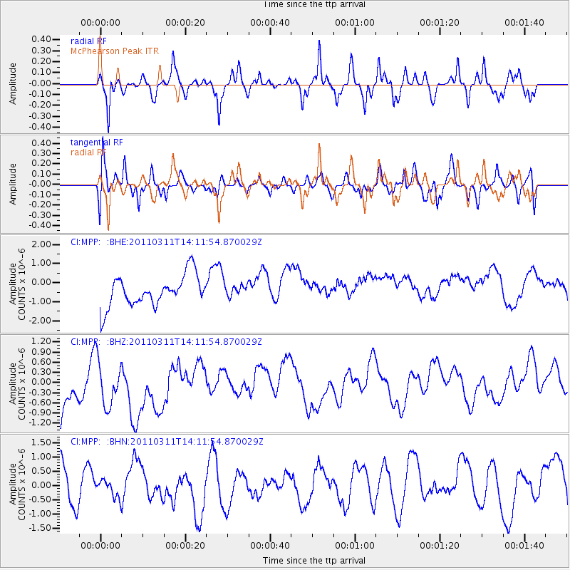
MPP McPhearson Peak - Earthquake Result Viewer
*The percent match for this event was below the threshold and hence no stack was calculated.
| Earthquake location: |
Near East Coast Of Honshu, Japan |
| Earthquake latitude/longitude: |
36.1/140.8 |
| Earthquake time(UTC): |
2011/03/11 (070) 14:00:38 GMT |
| Earthquake Depth: |
51 km |
| Earthquake Magnitude: |
5.5 MB, 5.4 MS |
| Earthquake Catalog/Contributor: |
WHDF/NEIC |
|
| Network: |
CI Caltech Regional Seismic Network |
| Station: |
MPP McPhearson Peak |
| Lat/Lon: |
34.89 N/119.81 W |
| Elevation: |
1739 m |
|
| Distance: |
77.0 deg |
| Az: |
56.341 deg |
| Baz: |
304.939 deg |
| Ray Param: |
$rayparam |
*The percent match for this event was below the threshold and hence was not used in the summary stack. |
|
| Radial Match: |
65.02234 % |
| Radial Bump: |
400 |
| Transverse Match: |
43.506542 % |
| Transverse Bump: |
400 |
| SOD ConfigId: |
356183 |
| Insert Time: |
2011-08-16 19:00:01.536 +0000 |
| GWidth: |
2.5 |
| Max Bumps: |
400 |
| Tol: |
0.001 |
|
Signal To Noise
| Channel | StoN | STA | LTA |
| CI:MPP: :BHZ:20110311T14:11:54.870029Z | 0.9303296 | 9.141306E-7 | 9.82588E-7 |
| CI:MPP: :BHN:20110311T14:11:54.870029Z | 0.5705615 | 3.233791E-7 | 5.6677345E-7 |
| CI:MPP: :BHE:20110311T14:11:54.870029Z | 0.37899265 | 3.061916E-7 | 8.0790903E-7 |
| Arrivals |
| Ps | |
| PpPs | |
| PsPs/PpSs | |


