You are here: Home > Network List > TA - USArray Transportable Network (new EarthScope stations) Stations List
> Station L02D Cave Junction, OR, USA > Earthquake Result Viewer
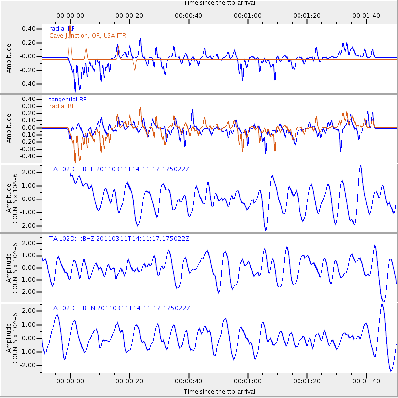
L02D Cave Junction, OR, USA - Earthquake Result Viewer
*The percent match for this event was below the threshold and hence no stack was calculated.
| Earthquake location: |
Near East Coast Of Honshu, Japan |
| Earthquake latitude/longitude: |
36.1/140.8 |
| Earthquake time(UTC): |
2011/03/11 (070) 14:00:38 GMT |
| Earthquake Depth: |
51 km |
| Earthquake Magnitude: |
5.5 MB, 5.4 MS |
| Earthquake Catalog/Contributor: |
WHDF/NEIC |
|
| Network: |
TA USArray Transportable Network (new EarthScope stations) |
| Station: |
L02D Cave Junction, OR, USA |
| Lat/Lon: |
42.16 N/123.60 W |
| Elevation: |
458 m |
|
| Distance: |
70.5 deg |
| Az: |
51.706 deg |
| Baz: |
301.284 deg |
| Ray Param: |
$rayparam |
*The percent match for this event was below the threshold and hence was not used in the summary stack. |
|
| Radial Match: |
61.988613 % |
| Radial Bump: |
318 |
| Transverse Match: |
50.29101 % |
| Transverse Bump: |
368 |
| SOD ConfigId: |
356183 |
| Insert Time: |
2011-08-16 19:45:55.815 +0000 |
| GWidth: |
2.5 |
| Max Bumps: |
400 |
| Tol: |
0.001 |
|
Signal To Noise
| Channel | StoN | STA | LTA |
| TA:L02D: :BHZ:20110311T14:11:17.175022Z | 0.561355 | 5.697733E-7 | 1.0149964E-6 |
| TA:L02D: :BHN:20110311T14:11:17.175022Z | 0.96979356 | 1.1025606E-6 | 1.1369025E-6 |
| TA:L02D: :BHE:20110311T14:11:17.175022Z | 0.85570955 | 8.3032086E-7 | 9.703302E-7 |
| Arrivals |
| Ps | |
| PpPs | |
| PsPs/PpSs | |


