You are here: Home > Network List > TA - USArray Transportable Network (new EarthScope stations) Stations List
> Station V39A Pettigrew, AR, USA > Earthquake Result Viewer
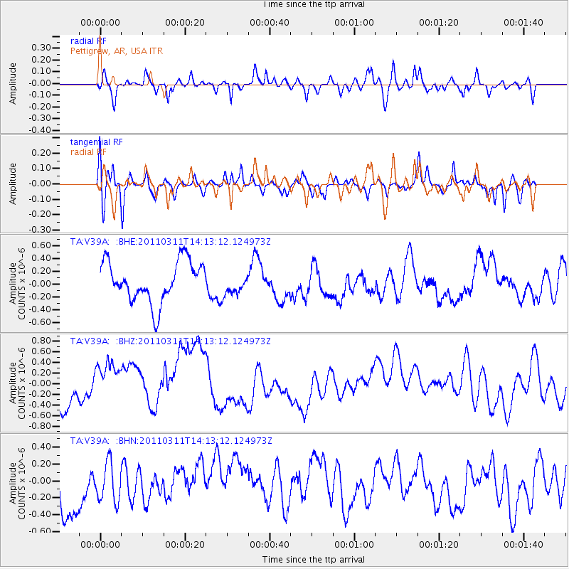
V39A Pettigrew, AR, USA - Earthquake Result Viewer
*The percent match for this event was below the threshold and hence no stack was calculated.
| Earthquake location: |
Near East Coast Of Honshu, Japan |
| Earthquake latitude/longitude: |
36.1/140.8 |
| Earthquake time(UTC): |
2011/03/11 (070) 14:00:38 GMT |
| Earthquake Depth: |
51 km |
| Earthquake Magnitude: |
5.5 MB, 5.4 MS |
| Earthquake Catalog/Contributor: |
WHDF/NEIC |
|
| Network: |
TA USArray Transportable Network (new EarthScope stations) |
| Station: |
V39A Pettigrew, AR, USA |
| Lat/Lon: |
35.84 N/93.64 W |
| Elevation: |
744 m |
|
| Distance: |
92.3 deg |
| Az: |
41.396 deg |
| Baz: |
318.783 deg |
| Ray Param: |
$rayparam |
*The percent match for this event was below the threshold and hence was not used in the summary stack. |
|
| Radial Match: |
46.32987 % |
| Radial Bump: |
393 |
| Transverse Match: |
51.272903 % |
| Transverse Bump: |
351 |
| SOD ConfigId: |
356183 |
| Insert Time: |
2011-08-16 20:27:27.586 +0000 |
| GWidth: |
2.5 |
| Max Bumps: |
400 |
| Tol: |
0.001 |
|
Signal To Noise
| Channel | StoN | STA | LTA |
| TA:V39A: :BHZ:20110311T14:13:12.124973Z | 2.559761 | 6.334997E-7 | 2.4748394E-7 |
| TA:V39A: :BHN:20110311T14:13:12.124973Z | 0.8405984 | 2.3480438E-7 | 2.7933004E-7 |
| TA:V39A: :BHE:20110311T14:13:12.124973Z | 0.4986015 | 1.5743068E-7 | 3.1574447E-7 |
| Arrivals |
| Ps | |
| PpPs | |
| PsPs/PpSs | |


