You are here: Home > Network List > TA - USArray Transportable Network (new EarthScope stations) Stations List
> Station R31A Burdett, KS, USA > Earthquake Result Viewer
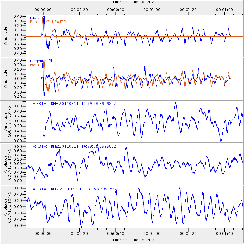
R31A Burdett, KS, USA - Earthquake Result Viewer
*The percent match for this event was below the threshold and hence no stack was calculated.
| Earthquake location: |
Off East Coast Of Honshu, Japan |
| Earthquake latitude/longitude: |
37.1/144.0 |
| Earthquake time(UTC): |
2011/03/11 (070) 14:27:57 GMT |
| Earthquake Depth: |
21 km |
| Earthquake Magnitude: |
5.5 MB |
| Earthquake Catalog/Contributor: |
WHDF/NEIC |
|
| Network: |
TA USArray Transportable Network (new EarthScope stations) |
| Station: |
R31A Burdett, KS, USA |
| Lat/Lon: |
38.29 N/99.53 W |
| Elevation: |
667 m |
|
| Distance: |
84.8 deg |
| Az: |
45.035 deg |
| Baz: |
314.047 deg |
| Ray Param: |
$rayparam |
*The percent match for this event was below the threshold and hence was not used in the summary stack. |
|
| Radial Match: |
52.96094 % |
| Radial Bump: |
400 |
| Transverse Match: |
55.00806 % |
| Transverse Bump: |
400 |
| SOD ConfigId: |
356183 |
| Insert Time: |
2011-08-16 21:58:48.489 +0000 |
| GWidth: |
2.5 |
| Max Bumps: |
400 |
| Tol: |
0.001 |
|
Signal To Noise
| Channel | StoN | STA | LTA |
| TA:R31A: :BHZ:20110311T14:39:58.399985Z | 2.3639526 | 3.6489084E-7 | 1.5435624E-7 |
| TA:R31A: :BHN:20110311T14:39:58.399985Z | 1.3719801 | 3.4969653E-7 | 2.5488455E-7 |
| TA:R31A: :BHE:20110311T14:39:58.399985Z | 1.7378962 | 3.3198017E-7 | 1.9102417E-7 |
| Arrivals |
| Ps | |
| PpPs | |
| PsPs/PpSs | |


