You are here: Home > Network List > TA - USArray Transportable Network (new EarthScope stations) Stations List
> Station F27A Lemmon, SD, USA > Earthquake Result Viewer
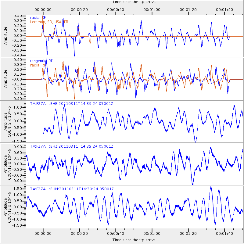
F27A Lemmon, SD, USA - Earthquake Result Viewer
*The percent match for this event was below the threshold and hence no stack was calculated.
| Earthquake location: |
Off East Coast Of Honshu, Japan |
| Earthquake latitude/longitude: |
37.1/144.0 |
| Earthquake time(UTC): |
2011/03/11 (070) 14:27:57 GMT |
| Earthquake Depth: |
21 km |
| Earthquake Magnitude: |
5.5 MB |
| Earthquake Catalog/Contributor: |
WHDF/NEIC |
|
| Network: |
TA USArray Transportable Network (new EarthScope stations) |
| Station: |
F27A Lemmon, SD, USA |
| Lat/Lon: |
45.87 N/102.02 W |
| Elevation: |
757 m |
|
| Distance: |
78.3 deg |
| Az: |
40.703 deg |
| Baz: |
311.74 deg |
| Ray Param: |
$rayparam |
*The percent match for this event was below the threshold and hence was not used in the summary stack. |
|
| Radial Match: |
55.14237 % |
| Radial Bump: |
332 |
| Transverse Match: |
55.966602 % |
| Transverse Bump: |
383 |
| SOD ConfigId: |
356183 |
| Insert Time: |
2011-08-16 22:03:29.693 +0000 |
| GWidth: |
2.5 |
| Max Bumps: |
400 |
| Tol: |
0.001 |
|
Signal To Noise
| Channel | StoN | STA | LTA |
| TA:F27A: :BHZ:20110311T14:39:24.05001Z | 0.7114708 | 3.8241683E-7 | 5.3750176E-7 |
| TA:F27A: :BHN:20110311T14:39:24.05001Z | 0.5895887 | 2.8299334E-7 | 4.7998435E-7 |
| TA:F27A: :BHE:20110311T14:39:24.05001Z | 0.47255144 | 2.8409272E-7 | 6.0118896E-7 |
| Arrivals |
| Ps | |
| PpPs | |
| PsPs/PpSs | |


