You are here: Home > Network List > TA - USArray Transportable Network (new EarthScope stations) Stations List
> Station A26A Wade Farm, Kenmare, ND, USA > Earthquake Result Viewer
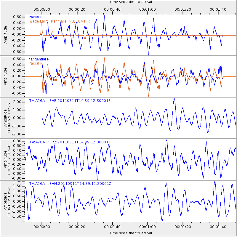
A26A Wade Farm, Kenmare, ND, USA - Earthquake Result Viewer
*The percent match for this event was below the threshold and hence no stack was calculated.
| Earthquake location: |
Off East Coast Of Honshu, Japan |
| Earthquake latitude/longitude: |
37.1/144.0 |
| Earthquake time(UTC): |
2011/03/11 (070) 14:27:57 GMT |
| Earthquake Depth: |
21 km |
| Earthquake Magnitude: |
5.5 MB |
| Earthquake Catalog/Contributor: |
WHDF/NEIC |
|
| Network: |
TA USArray Transportable Network (new EarthScope stations) |
| Station: |
A26A Wade Farm, Kenmare, ND, USA |
| Lat/Lon: |
48.90 N/102.04 W |
| Elevation: |
570 m |
|
| Distance: |
76.3 deg |
| Az: |
38.387 deg |
| Baz: |
311.217 deg |
| Ray Param: |
$rayparam |
*The percent match for this event was below the threshold and hence was not used in the summary stack. |
|
| Radial Match: |
48.768208 % |
| Radial Bump: |
400 |
| Transverse Match: |
42.69726 % |
| Transverse Bump: |
400 |
| SOD ConfigId: |
356183 |
| Insert Time: |
2011-08-16 22:03:52.989 +0000 |
| GWidth: |
2.5 |
| Max Bumps: |
400 |
| Tol: |
0.001 |
|
Signal To Noise
| Channel | StoN | STA | LTA |
| TA:A26A: :BHZ:20110311T14:39:12.80001Z | 0.90723115 | 2.8715468E-7 | 3.1651766E-7 |
| TA:A26A: :BHN:20110311T14:39:12.80001Z | 0.54159033 | 5.2715035E-7 | 9.733378E-7 |
| TA:A26A: :BHE:20110311T14:39:12.80001Z | 0.8017882 | 4.56569E-7 | 5.694384E-7 |
| Arrivals |
| Ps | |
| PpPs | |
| PsPs/PpSs | |


