You are here: Home > Network List > IU - Global Seismograph Network (GSN - IRIS/USGS) Stations List
> Station POHA Pohakuloa, Hawaii, USA > Earthquake Result Viewer
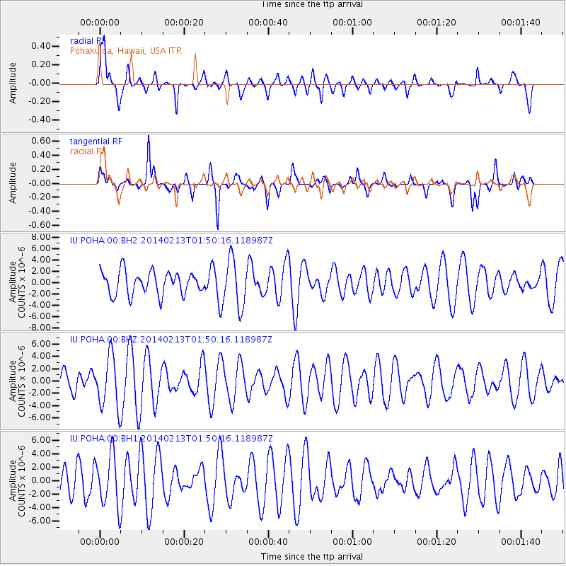
POHA Pohakuloa, Hawaii, USA - Earthquake Result Viewer
*The percent match for this event was below the threshold and hence no stack was calculated.
| Earthquake location: |
South Of Kermadec Islands |
| Earthquake latitude/longitude: |
-32.8/-178.7 |
| Earthquake time(UTC): |
2014/02/13 (044) 01:41:05 GMT |
| Earthquake Depth: |
33 km |
| Earthquake Magnitude: |
5.0 MW |
| Earthquake Catalog/Contributor: |
ISC/ISC |
|
| Network: |
IU Global Seismograph Network (GSN - IRIS/USGS) |
| Station: |
POHA Pohakuloa, Hawaii, USA |
| Lat/Lon: |
19.76 N/155.53 W |
| Elevation: |
1990 m |
|
| Distance: |
56.8 deg |
| Az: |
26.324 deg |
| Baz: |
203.361 deg |
| Ray Param: |
$rayparam |
*The percent match for this event was below the threshold and hence was not used in the summary stack. |
|
| Radial Match: |
50.090107 % |
| Radial Bump: |
400 |
| Transverse Match: |
65.54872 % |
| Transverse Bump: |
400 |
| SOD ConfigId: |
3390531 |
| Insert Time: |
2019-04-10 08:19:16.703 +0000 |
| GWidth: |
2.5 |
| Max Bumps: |
400 |
| Tol: |
0.001 |
|
Signal To Noise
| Channel | StoN | STA | LTA |
| IU:POHA:00:BHZ:20140213T01:50:16.118987Z | 2.294509 | 4.281791E-6 | 1.8661034E-6 |
| IU:POHA:00:BH1:20140213T01:50:16.118987Z | 1.4608321 | 3.850139E-6 | 2.6355792E-6 |
| IU:POHA:00:BH2:20140213T01:50:16.118987Z | 2.166504 | 4.3415694E-6 | 2.0039517E-6 |
| Arrivals |
| Ps | |
| PpPs | |
| PsPs/PpSs | |


