You are here: Home > Network List > TA - USArray Transportable Network (new EarthScope stations) Stations List
> Station 635A Leesville, TX, USA > Earthquake Result Viewer
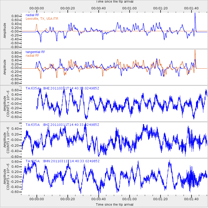
635A Leesville, TX, USA - Earthquake Result Viewer
*The percent match for this event was below the threshold and hence no stack was calculated.
| Earthquake location: |
Off East Coast Of Honshu, Japan |
| Earthquake latitude/longitude: |
37.1/144.0 |
| Earthquake time(UTC): |
2011/03/11 (070) 14:27:57 GMT |
| Earthquake Depth: |
21 km |
| Earthquake Magnitude: |
5.5 MB |
| Earthquake Catalog/Contributor: |
WHDF/NEIC |
|
| Network: |
TA USArray Transportable Network (new EarthScope stations) |
| Station: |
635A Leesville, TX, USA |
| Lat/Lon: |
29.39 N/97.77 W |
| Elevation: |
119 m |
|
| Distance: |
92.1 deg |
| Az: |
50.328 deg |
| Baz: |
315.167 deg |
| Ray Param: |
$rayparam |
*The percent match for this event was below the threshold and hence was not used in the summary stack. |
|
| Radial Match: |
49.889404 % |
| Radial Bump: |
363 |
| Transverse Match: |
46.51916 % |
| Transverse Bump: |
362 |
| SOD ConfigId: |
356183 |
| Insert Time: |
2011-08-16 22:16:04.997 +0000 |
| GWidth: |
2.5 |
| Max Bumps: |
400 |
| Tol: |
0.001 |
|
Signal To Noise
| Channel | StoN | STA | LTA |
| TA:635A: :BHZ:20110311T14:40:33.024985Z | 0.8036776 | 1.5296794E-7 | 1.9033494E-7 |
| TA:635A: :BHN:20110311T14:40:33.024985Z | 0.71468794 | 4.8298784E-7 | 6.758024E-7 |
| TA:635A: :BHE:20110311T14:40:33.024985Z | 1.4228932 | 4.4162968E-7 | 3.1037445E-7 |
| Arrivals |
| Ps | |
| PpPs | |
| PsPs/PpSs | |


