You are here: Home > Network List > TA - USArray Transportable Network (new EarthScope stations) Stations List
> Station S39A Bolivar, MO, USA > Earthquake Result Viewer
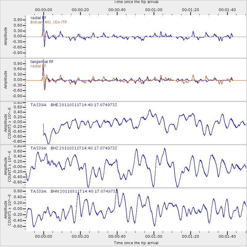
S39A Bolivar, MO, USA - Earthquake Result Viewer
*The percent match for this event was below the threshold and hence no stack was calculated.
| Earthquake location: |
Off East Coast Of Honshu, Japan |
| Earthquake latitude/longitude: |
37.1/144.0 |
| Earthquake time(UTC): |
2011/03/11 (070) 14:27:57 GMT |
| Earthquake Depth: |
21 km |
| Earthquake Magnitude: |
5.5 MB |
| Earthquake Catalog/Contributor: |
WHDF/NEIC |
|
| Network: |
TA USArray Transportable Network (new EarthScope stations) |
| Station: |
S39A Bolivar, MO, USA |
| Lat/Lon: |
37.69 N/93.32 W |
| Elevation: |
331 m |
|
| Distance: |
88.6 deg |
| Az: |
41.928 deg |
| Baz: |
317.675 deg |
| Ray Param: |
$rayparam |
*The percent match for this event was below the threshold and hence was not used in the summary stack. |
|
| Radial Match: |
52.50839 % |
| Radial Bump: |
400 |
| Transverse Match: |
57.812943 % |
| Transverse Bump: |
400 |
| SOD ConfigId: |
356183 |
| Insert Time: |
2011-08-16 22:50:03.952 +0000 |
| GWidth: |
2.5 |
| Max Bumps: |
400 |
| Tol: |
0.001 |
|
Signal To Noise
| Channel | StoN | STA | LTA |
| TA:S39A: :BHZ:20110311T14:40:17.074973Z | 1.9415476 | 6.041513E-7 | 3.1116997E-7 |
| TA:S39A: :BHN:20110311T14:40:17.074973Z | 0.9078916 | 5.6982526E-7 | 6.276358E-7 |
| TA:S39A: :BHE:20110311T14:40:17.074973Z | 0.78161013 | 2.0313796E-7 | 2.5989678E-7 |
| Arrivals |
| Ps | |
| PpPs | |
| PsPs/PpSs | |


