You are here: Home > Network List > WY - Yellowstone Wyoming Seismic Network Stations List
> Station YHH Holmes Hill, YNP, WY, USA > Earthquake Result Viewer
YHH Holmes Hill, YNP, WY, USA - Earthquake Result Viewer
*The percent match for this event was below the threshold and hence no stack was calculated.
| Earthquake location: |
Easter Island Region |
| Earthquake latitude/longitude: |
-23.0/-114.3 |
| Earthquake time(UTC): |
2014/02/14 (045) 07:44:15 GMT |
| Earthquake Depth: |
12 km |
| Earthquake Magnitude: |
5.6 MWW, 5.5 MWB, 5.6 MWC |
| Earthquake Catalog/Contributor: |
NEIC PDE/NEIC COMCAT |
|
| Network: |
WY Yellowstone Wyoming Seismic Network |
| Station: |
YHH Holmes Hill, YNP, WY, USA |
| Lat/Lon: |
44.79 N/110.85 W |
| Elevation: |
2717 m |
|
| Distance: |
67.5 deg |
| Az: |
2.682 deg |
| Baz: |
183.472 deg |
| Ray Param: |
$rayparam |
*The percent match for this event was below the threshold and hence was not used in the summary stack. |
|
| Radial Match: |
47.361126 % |
| Radial Bump: |
243 |
| Transverse Match: |
59.3819 % |
| Transverse Bump: |
356 |
| SOD ConfigId: |
3390531 |
| Insert Time: |
2019-04-10 08:27:34.295 +0000 |
| GWidth: |
2.5 |
| Max Bumps: |
400 |
| Tol: |
0.001 |
|
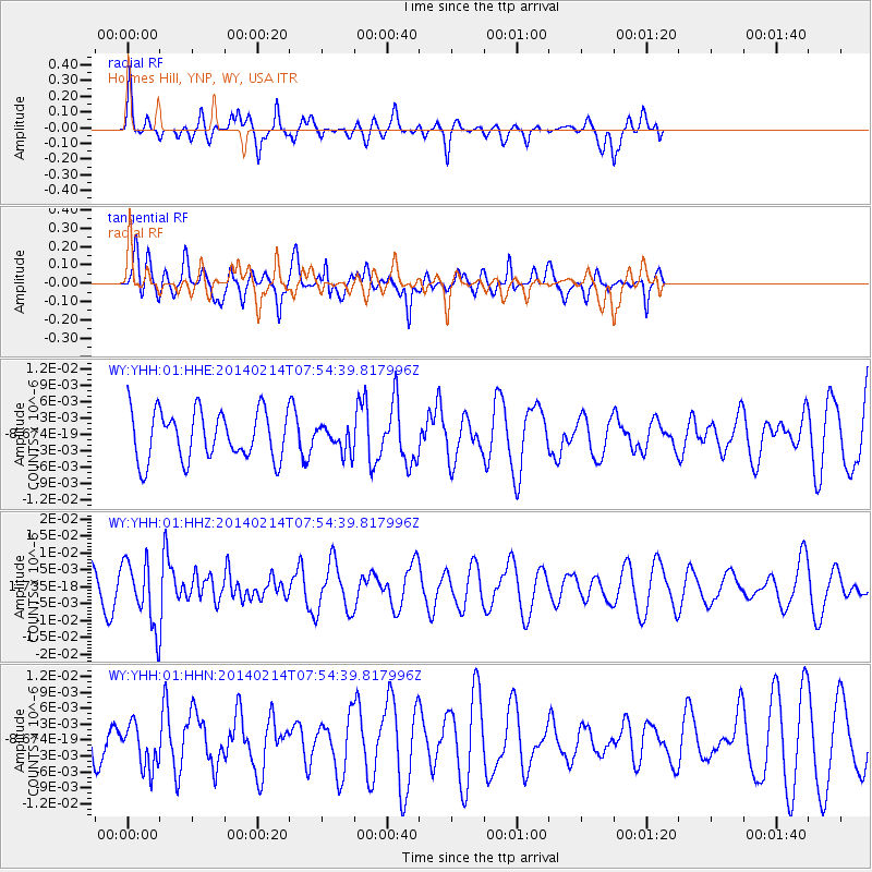
Signal To Noise
| Channel | StoN | STA | LTA |
| WY:YHH:01:HHZ:20140214T07:54:39.817996Z | 1.9616376 | 9.464503E-9 | 4.8247966E-9 |
| WY:YHH:01:HHN:20140214T07:54:39.817996Z | 1.1637164 | 4.175326E-9 | 3.5879237E-9 |
| WY:YHH:01:HHE:20140214T07:54:39.817996Z | 0.46601492 | 2.0869593E-9 | 4.47831E-9 |
| Arrivals |
| Ps | |
| PpPs | |
| PsPs/PpSs | |


