You are here: Home > Network List > IC - New China Digital Seismograph Network Stations List
> Station KMI Kunming, Yunnan Province, China > Earthquake Result Viewer
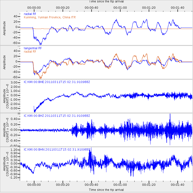
KMI Kunming, Yunnan Province, China - Earthquake Result Viewer
*The percent match for this event was below the threshold and hence no stack was calculated.
| Earthquake location: |
Near East Coast Of Honshu, Japan |
| Earthquake latitude/longitude: |
36.0/141.4 |
| Earthquake time(UTC): |
2011/03/11 (070) 14:56:11 GMT |
| Earthquake Depth: |
10 km |
| Earthquake Magnitude: |
5.8 MB |
| Earthquake Catalog/Contributor: |
WHDF/NEIC |
|
| Network: |
IC New China Digital Seismograph Network |
| Station: |
KMI Kunming, Yunnan Province, China |
| Lat/Lon: |
25.12 N/102.74 E |
| Elevation: |
1975 m |
|
| Distance: |
34.8 deg |
| Az: |
262.828 deg |
| Baz: |
62.621 deg |
| Ray Param: |
$rayparam |
*The percent match for this event was below the threshold and hence was not used in the summary stack. |
|
| Radial Match: |
44.931606 % |
| Radial Bump: |
400 |
| Transverse Match: |
61.673176 % |
| Transverse Bump: |
400 |
| SOD ConfigId: |
356183 |
| Insert Time: |
2011-08-16 23:51:06.759 +0000 |
| GWidth: |
2.5 |
| Max Bumps: |
400 |
| Tol: |
0.001 |
|
Signal To Noise
| Channel | StoN | STA | LTA |
| IC:KMI:00:BHZ:20110311T15:02:31.910988Z | 0.5575853 | 2.0894692E-8 | 3.7473534E-8 |
| IC:KMI:00:BHN:20110311T15:02:31.910988Z | 1.0737944 | 5.429985E-7 | 5.0568207E-7 |
| IC:KMI:00:BHE:20110311T15:02:31.910988Z | 1.3909079 | 1.4482858E-6 | 1.0412521E-6 |
| Arrivals |
| Ps | |
| PpPs | |
| PsPs/PpSs | |


