You are here: Home > Network List > TA - USArray Transportable Network (new EarthScope stations) Stations List
> Station BGNE Belgrade, NE, USA > Earthquake Result Viewer
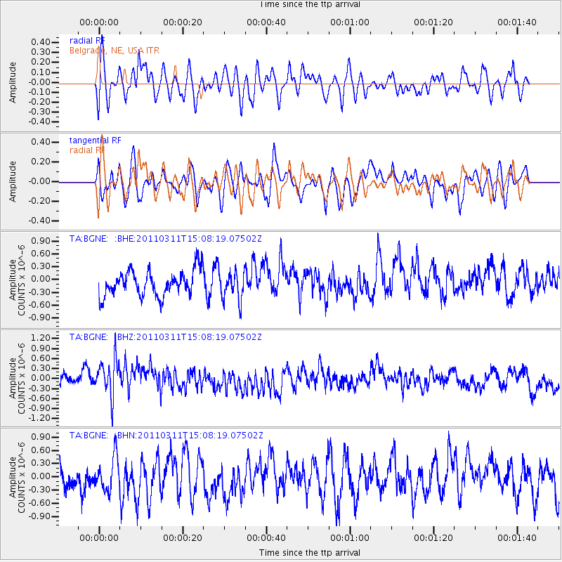
BGNE Belgrade, NE, USA - Earthquake Result Viewer
*The percent match for this event was below the threshold and hence no stack was calculated.
| Earthquake location: |
Near East Coast Of Honshu, Japan |
| Earthquake latitude/longitude: |
36.0/141.4 |
| Earthquake time(UTC): |
2011/03/11 (070) 14:56:11 GMT |
| Earthquake Depth: |
10 km |
| Earthquake Magnitude: |
5.8 MB |
| Earthquake Catalog/Contributor: |
WHDF/NEIC |
|
| Network: |
TA USArray Transportable Network (new EarthScope stations) |
| Station: |
BGNE Belgrade, NE, USA |
| Lat/Lon: |
41.41 N/98.15 W |
| Elevation: |
573 m |
|
| Distance: |
85.6 deg |
| Az: |
40.569 deg |
| Baz: |
315.457 deg |
| Ray Param: |
$rayparam |
*The percent match for this event was below the threshold and hence was not used in the summary stack. |
|
| Radial Match: |
53.614567 % |
| Radial Bump: |
400 |
| Transverse Match: |
51.166798 % |
| Transverse Bump: |
400 |
| SOD ConfigId: |
356183 |
| Insert Time: |
2011-08-17 00:13:24.256 +0000 |
| GWidth: |
2.5 |
| Max Bumps: |
400 |
| Tol: |
0.001 |
|
Signal To Noise
| Channel | StoN | STA | LTA |
| TA:BGNE: :BHZ:20110311T15:08:19.07502Z | 2.1276126 | 6.1355377E-7 | 2.883766E-7 |
| TA:BGNE: :BHN:20110311T15:08:19.07502Z | 1.1182922 | 3.8865204E-7 | 3.475407E-7 |
| TA:BGNE: :BHE:20110311T15:08:19.07502Z | 1.102637 | 3.287683E-7 | 2.9816545E-7 |
| Arrivals |
| Ps | |
| PpPs | |
| PsPs/PpSs | |


