You are here: Home > Network List > TA - USArray Transportable Network (new EarthScope stations) Stations List
> Station P28A Satin Francis, KS, USA > Earthquake Result Viewer
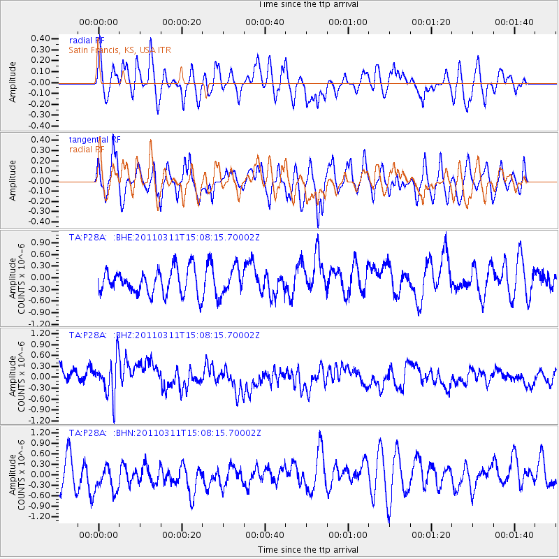
P28A Satin Francis, KS, USA - Earthquake Result Viewer
*The percent match for this event was below the threshold and hence no stack was calculated.
| Earthquake location: |
Near East Coast Of Honshu, Japan |
| Earthquake latitude/longitude: |
36.0/141.4 |
| Earthquake time(UTC): |
2011/03/11 (070) 14:56:11 GMT |
| Earthquake Depth: |
10 km |
| Earthquake Magnitude: |
5.8 MB |
| Earthquake Catalog/Contributor: |
WHDF/NEIC |
|
| Network: |
TA USArray Transportable Network (new EarthScope stations) |
| Station: |
P28A Satin Francis, KS, USA |
| Lat/Lon: |
39.57 N/101.75 W |
| Elevation: |
1105 m |
|
| Distance: |
85.0 deg |
| Az: |
43.813 deg |
| Baz: |
313.39 deg |
| Ray Param: |
$rayparam |
*The percent match for this event was below the threshold and hence was not used in the summary stack. |
|
| Radial Match: |
55.403122 % |
| Radial Bump: |
400 |
| Transverse Match: |
50.181515 % |
| Transverse Bump: |
400 |
| SOD ConfigId: |
356183 |
| Insert Time: |
2011-08-17 00:18:07.268 +0000 |
| GWidth: |
2.5 |
| Max Bumps: |
400 |
| Tol: |
0.001 |
|
Signal To Noise
| Channel | StoN | STA | LTA |
| TA:P28A: :BHZ:20110311T15:08:15.70002Z | 1.7064704 | 5.5564584E-7 | 3.2561118E-7 |
| TA:P28A: :BHN:20110311T15:08:15.70002Z | 1.3532586 | 5.4764644E-7 | 4.046872E-7 |
| TA:P28A: :BHE:20110311T15:08:15.70002Z | 1.0638688 | 3.420682E-7 | 3.2153233E-7 |
| Arrivals |
| Ps | |
| PpPs | |
| PsPs/PpSs | |


