You are here: Home > Network List > UW - Pacific Northwest Regional Seismic Network Stations List
> Station MRBL Marblemount, WA, USA > Earthquake Result Viewer
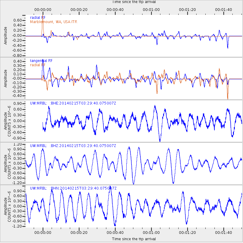
MRBL Marblemount, WA, USA - Earthquake Result Viewer
*The percent match for this event was below the threshold and hence no stack was calculated.
| Earthquake location: |
Georgia, USA |
| Earthquake latitude/longitude: |
33.8/-82.1 |
| Earthquake time(UTC): |
2014/02/15 (046) 03:23:38 GMT |
| Earthquake Depth: |
8.2 km |
| Earthquake Magnitude: |
4.5 mb |
| Earthquake Catalog/Contributor: |
ISC/ISC |
|
| Network: |
UW Pacific Northwest Regional Seismic Network |
| Station: |
MRBL Marblemount, WA, USA |
| Lat/Lon: |
48.52 N/121.48 W |
| Elevation: |
75 m |
|
| Distance: |
32.7 deg |
| Az: |
308.673 deg |
| Baz: |
102.066 deg |
| Ray Param: |
$rayparam |
*The percent match for this event was below the threshold and hence was not used in the summary stack. |
|
| Radial Match: |
58.68613 % |
| Radial Bump: |
400 |
| Transverse Match: |
39.753666 % |
| Transverse Bump: |
400 |
| SOD ConfigId: |
3390531 |
| Insert Time: |
2019-04-10 08:32:03.040 +0000 |
| GWidth: |
2.5 |
| Max Bumps: |
400 |
| Tol: |
0.001 |
|
Signal To Noise
| Channel | StoN | STA | LTA |
| UW:MRBL: :BHZ:20140215T03:29:40.075007Z | 3.0215254 | 5.5787297E-7 | 1.8463291E-7 |
| UW:MRBL: :BHN:20140215T03:29:40.075007Z | 1.0187131 | 5.374346E-7 | 5.2756224E-7 |
| UW:MRBL: :BHE:20140215T03:29:40.075007Z | 1.7415968 | 4.260751E-7 | 2.4464623E-7 |
| Arrivals |
| Ps | |
| PpPs | |
| PsPs/PpSs | |


