You are here: Home > Network List > TA - USArray Transportable Network (new EarthScope stations) Stations List
> Station X33A Lawton, OK, USA > Earthquake Result Viewer
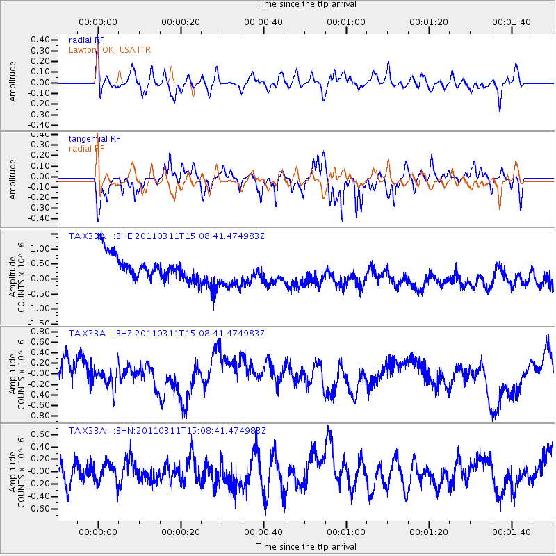
X33A Lawton, OK, USA - Earthquake Result Viewer
*The percent match for this event was below the threshold and hence no stack was calculated.
| Earthquake location: |
Near East Coast Of Honshu, Japan |
| Earthquake latitude/longitude: |
36.0/141.4 |
| Earthquake time(UTC): |
2011/03/11 (070) 14:56:11 GMT |
| Earthquake Depth: |
10 km |
| Earthquake Magnitude: |
5.8 MB |
| Earthquake Catalog/Contributor: |
WHDF/NEIC |
|
| Network: |
TA USArray Transportable Network (new EarthScope stations) |
| Station: |
X33A Lawton, OK, USA |
| Lat/Lon: |
34.54 N/98.50 W |
| Elevation: |
346 m |
|
| Distance: |
90.3 deg |
| Az: |
45.579 deg |
| Baz: |
315.418 deg |
| Ray Param: |
$rayparam |
*The percent match for this event was below the threshold and hence was not used in the summary stack. |
|
| Radial Match: |
52.71835 % |
| Radial Bump: |
400 |
| Transverse Match: |
72.474495 % |
| Transverse Bump: |
400 |
| SOD ConfigId: |
356183 |
| Insert Time: |
2011-08-17 00:36:33.533 +0000 |
| GWidth: |
2.5 |
| Max Bumps: |
400 |
| Tol: |
0.001 |
|
Signal To Noise
| Channel | StoN | STA | LTA |
| TA:X33A: :BHZ:20110311T15:08:41.474983Z | 0.6522069 | 1.9790073E-7 | 3.0343244E-7 |
| TA:X33A: :BHN:20110311T15:08:41.474983Z | 0.62955546 | 2.0270626E-7 | 3.2198318E-7 |
| TA:X33A: :BHE:20110311T15:08:41.474983Z | 1.4177403 | 5.7305436E-7 | 4.042026E-7 |
| Arrivals |
| Ps | |
| PpPs | |
| PsPs/PpSs | |


