You are here: Home > Network List > TA - USArray Transportable Network (new EarthScope stations) Stations List
> Station Z38A Mt. Pleasant, TX, USA > Earthquake Result Viewer
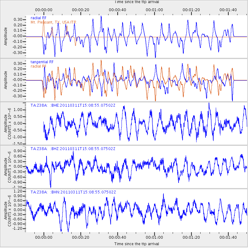
Z38A Mt. Pleasant, TX, USA - Earthquake Result Viewer
*The percent match for this event was below the threshold and hence no stack was calculated.
| Earthquake location: |
Near East Coast Of Honshu, Japan |
| Earthquake latitude/longitude: |
36.0/141.4 |
| Earthquake time(UTC): |
2011/03/11 (070) 14:56:11 GMT |
| Earthquake Depth: |
10 km |
| Earthquake Magnitude: |
5.8 MB |
| Earthquake Catalog/Contributor: |
WHDF/NEIC |
|
| Network: |
TA USArray Transportable Network (new EarthScope stations) |
| Station: |
Z38A Mt. Pleasant, TX, USA |
| Lat/Lon: |
33.25 N/94.99 W |
| Elevation: |
116 m |
|
| Distance: |
93.3 deg |
| Az: |
44.348 deg |
| Baz: |
317.409 deg |
| Ray Param: |
$rayparam |
*The percent match for this event was below the threshold and hence was not used in the summary stack. |
|
| Radial Match: |
55.575436 % |
| Radial Bump: |
392 |
| Transverse Match: |
41.47641 % |
| Transverse Bump: |
400 |
| SOD ConfigId: |
356183 |
| Insert Time: |
2011-08-17 00:49:41.859 +0000 |
| GWidth: |
2.5 |
| Max Bumps: |
400 |
| Tol: |
0.001 |
|
Signal To Noise
| Channel | StoN | STA | LTA |
| TA:Z38A: :BHZ:20110311T15:08:55.07502Z | 1.4720643 | 4.6903352E-7 | 3.18623E-7 |
| TA:Z38A: :BHN:20110311T15:08:55.07502Z | 0.66269785 | 2.6421944E-7 | 3.9870272E-7 |
| TA:Z38A: :BHE:20110311T15:08:55.07502Z | 0.6368808 | 3.1319135E-7 | 4.9175816E-7 |
| Arrivals |
| Ps | |
| PpPs | |
| PsPs/PpSs | |


