You are here: Home > Network List > IU - Global Seismograph Network (GSN - IRIS/USGS) Stations List
> Station POHA Pohakuloa, Hawaii, USA > Earthquake Result Viewer
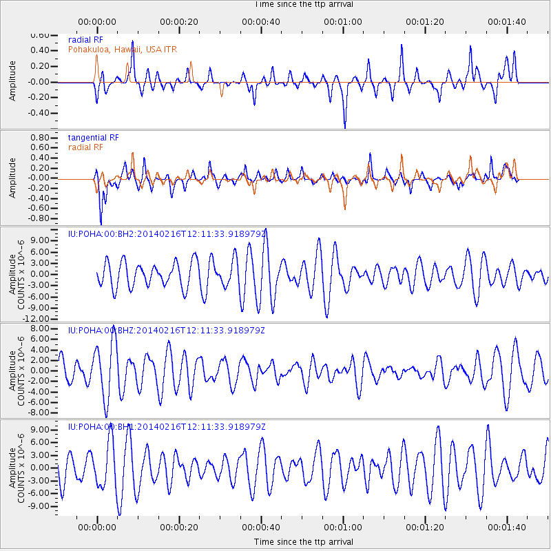
POHA Pohakuloa, Hawaii, USA - Earthquake Result Viewer
*The percent match for this event was below the threshold and hence no stack was calculated.
| Earthquake location: |
Talaud Islands, Indonesia |
| Earthquake latitude/longitude: |
4.8/126.1 |
| Earthquake time(UTC): |
2014/02/16 (047) 12:00:24 GMT |
| Earthquake Depth: |
134 km |
| Earthquake Magnitude: |
4.9 MW |
| Earthquake Catalog/Contributor: |
ISC/ISC |
|
| Network: |
IU Global Seismograph Network (GSN - IRIS/USGS) |
| Station: |
POHA Pohakuloa, Hawaii, USA |
| Lat/Lon: |
19.76 N/155.53 W |
| Elevation: |
1990 m |
|
| Distance: |
77.4 deg |
| Az: |
70.93 deg |
| Baz: |
270.667 deg |
| Ray Param: |
$rayparam |
*The percent match for this event was below the threshold and hence was not used in the summary stack. |
|
| Radial Match: |
57.938263 % |
| Radial Bump: |
326 |
| Transverse Match: |
67.235466 % |
| Transverse Bump: |
400 |
| SOD ConfigId: |
3390531 |
| Insert Time: |
2019-04-10 08:33:50.220 +0000 |
| GWidth: |
2.5 |
| Max Bumps: |
400 |
| Tol: |
0.001 |
|
Signal To Noise
| Channel | StoN | STA | LTA |
| IU:POHA:00:BHZ:20140216T12:11:33.918979Z | 2.7009907 | 5.6143576E-6 | 2.078629E-6 |
| IU:POHA:00:BH1:20140216T12:11:33.918979Z | 0.9866627 | 5.4974266E-6 | 5.5717387E-6 |
| IU:POHA:00:BH2:20140216T12:11:33.918979Z | 1.0413653 | 3.3610459E-6 | 3.2275377E-6 |
| Arrivals |
| Ps | |
| PpPs | |
| PsPs/PpSs | |


