You are here: Home > Network List > US - United States National Seismic Network Stations List
> Station WMOK Wichita Mountains, Oklahoma, USA > Earthquake Result Viewer
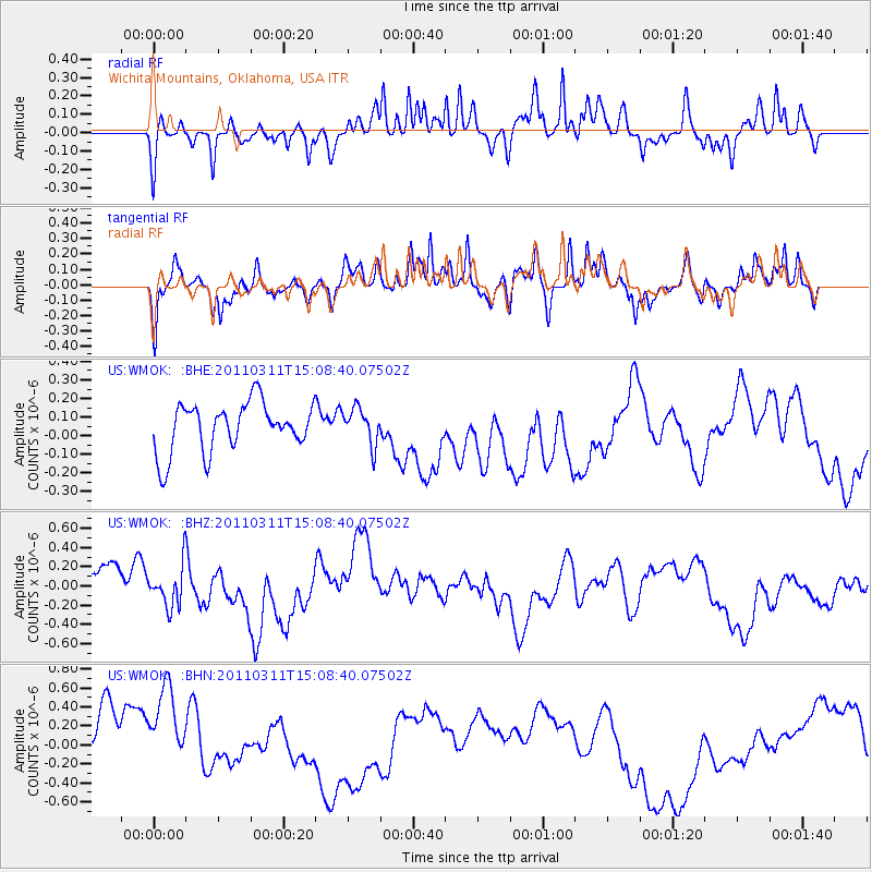
WMOK Wichita Mountains, Oklahoma, USA - Earthquake Result Viewer
*The percent match for this event was below the threshold and hence no stack was calculated.
| Earthquake location: |
Near East Coast Of Honshu, Japan |
| Earthquake latitude/longitude: |
36.0/141.4 |
| Earthquake time(UTC): |
2011/03/11 (070) 14:56:11 GMT |
| Earthquake Depth: |
10 km |
| Earthquake Magnitude: |
5.8 MB |
| Earthquake Catalog/Contributor: |
WHDF/NEIC |
|
| Network: |
US United States National Seismic Network |
| Station: |
WMOK Wichita Mountains, Oklahoma, USA |
| Lat/Lon: |
34.74 N/98.78 W |
| Elevation: |
486 m |
|
| Distance: |
90.0 deg |
| Az: |
45.605 deg |
| Baz: |
315.259 deg |
| Ray Param: |
$rayparam |
*The percent match for this event was below the threshold and hence was not used in the summary stack. |
|
| Radial Match: |
49.327038 % |
| Radial Bump: |
341 |
| Transverse Match: |
35.852615 % |
| Transverse Bump: |
319 |
| SOD ConfigId: |
356183 |
| Insert Time: |
2011-08-17 01:31:48.389 +0000 |
| GWidth: |
2.5 |
| Max Bumps: |
400 |
| Tol: |
0.001 |
|
Signal To Noise
| Channel | StoN | STA | LTA |
| US:WMOK: :BHZ:20110311T15:08:40.07502Z | 0.6979318 | 2.0498564E-7 | 2.9370437E-7 |
| US:WMOK: :BHN:20110311T15:08:40.07502Z | 0.91033506 | 8.558936E-7 | 9.4019623E-7 |
| US:WMOK: :BHE:20110311T15:08:40.07502Z | 0.7412365 | 9.743502E-8 | 1.314493E-7 |
| Arrivals |
| Ps | |
| PpPs | |
| PsPs/PpSs | |


