You are here: Home > Network List > US - United States National Seismic Network Stations List
> Station HAWA Hanford, Washington, USA > Earthquake Result Viewer
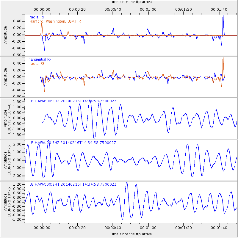
HAWA Hanford, Washington, USA - Earthquake Result Viewer
*The percent match for this event was below the threshold and hence no stack was calculated.
| Earthquake location: |
Eastern New Guinea Reg., P.N.G. |
| Earthquake latitude/longitude: |
-7.0/146.8 |
| Earthquake time(UTC): |
2014/02/16 (047) 14:22:06 GMT |
| Earthquake Depth: |
88 km |
| Earthquake Magnitude: |
5.0 MW |
| Earthquake Catalog/Contributor: |
ISC/ISC |
|
| Network: |
US United States National Seismic Network |
| Station: |
HAWA Hanford, Washington, USA |
| Lat/Lon: |
46.39 N/119.53 W |
| Elevation: |
364 m |
|
| Distance: |
97.5 deg |
| Az: |
44.164 deg |
| Baz: |
267.798 deg |
| Ray Param: |
$rayparam |
*The percent match for this event was below the threshold and hence was not used in the summary stack. |
|
| Radial Match: |
70.839424 % |
| Radial Bump: |
400 |
| Transverse Match: |
55.80461 % |
| Transverse Bump: |
400 |
| SOD ConfigId: |
3390531 |
| Insert Time: |
2019-04-10 08:37:52.026 +0000 |
| GWidth: |
2.5 |
| Max Bumps: |
400 |
| Tol: |
0.001 |
|
Signal To Noise
| Channel | StoN | STA | LTA |
| US:HAWA:00:BHZ:20140216T14:34:58.750002Z | 1.8456727 | 1.6457326E-6 | 8.916709E-7 |
| US:HAWA:00:BH1:20140216T14:34:58.750002Z | 0.94542044 | 4.3140983E-7 | 4.5631535E-7 |
| US:HAWA:00:BH2:20140216T14:34:58.750002Z | 1.9418937 | 1.1841945E-6 | 6.098143E-7 |
| Arrivals |
| Ps | |
| PpPs | |
| PsPs/PpSs | |


