You are here: Home > Network List > AZ - ANZA Regional Network Stations List
> Station PFO AZ.PFO > Earthquake Result Viewer
PFO AZ.PFO - Earthquake Result Viewer
| Earthquake location: |
Kuril Islands |
| Earthquake latitude/longitude: |
44.2/150.0 |
| Earthquake time(UTC): |
1995/12/10 (344) 22:48:08 GMT |
| Earthquake Depth: |
33 km |
| Earthquake Magnitude: |
5.5 MB, 6.2 MS |
| Earthquake Catalog/Contributor: |
WHDF/NEIC |
|
| Network: |
AZ ANZA Regional Network |
| Station: |
PFO AZ.PFO |
| Lat/Lon: |
33.61 N/116.46 W |
| Elevation: |
1259 m |
|
| Distance: |
69.8 deg |
| Az: |
62.564 deg |
| Baz: |
310.139 deg |
| Ray Param: |
0.055363044 |
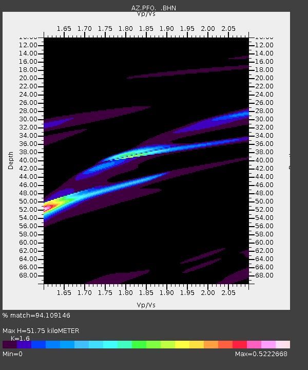
| Estimated Moho Depth: |
51.75 km |
| Estimated Crust Vp/Vs: |
1.60 |
| Assumed Crust Vp: |
6.264 km/s |
| Estimated Crust Vs: |
3.915 km/s |
| Estimated Crust Poisson's Ratio: |
0.18 |
|
| Radial Match: |
94.109146 % |
| Radial Bump: |
371 |
| Transverse Match: |
63.513515 % |
| Transverse Bump: |
400 |
| SOD ConfigId: |
6273 |
| Insert Time: |
2010-02-26 20:11:48.363 +0000 |
| GWidth: |
2.5 |
| Max Bumps: |
400 |
| Tol: |
0.001 |
|

Signal To Noise
| Channel | StoN | STA | LTA |
| AZ:PFO: :BHN:19951210T22:58:44.398999Z | 0.7890425 | 1.0704971E-6 | 1.356704E-6 |
| AZ:PFO: :BHE:19951210T22:58:44.398999Z | 1.8857443 | 2.5307486E-6 | 1.3420422E-6 |
| AZ:PFO: :BHZ:19951210T22:58:44.398999Z | 1.4718268 | 2.2320878E-6 | 1.5165424E-6 |
| Arrivals |
| Ps | 5.2 SECOND |
| PpPs | 21 SECOND |
| PsPs/PpSs | 26 SECOND |


