You are here: Home > Network List > TA - USArray Transportable Network (new EarthScope stations) Stations List
> Station 121A Cookes Peak, Deming, NM, USA > Earthquake Result Viewer
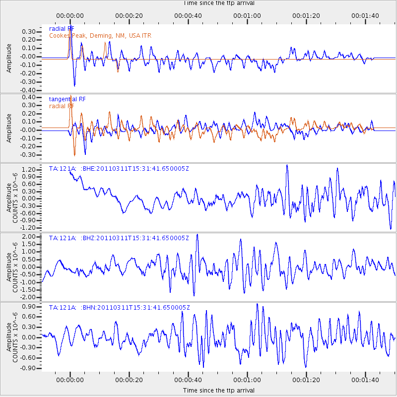
121A Cookes Peak, Deming, NM, USA - Earthquake Result Viewer
*The percent match for this event was below the threshold and hence no stack was calculated.
| Earthquake location: |
Near East Coast Of Honshu, Japan |
| Earthquake latitude/longitude: |
36.2/141.9 |
| Earthquake time(UTC): |
2011/03/11 (070) 15:19:38 GMT |
| Earthquake Depth: |
35 km |
| Earthquake Magnitude: |
5.5 MB |
| Earthquake Catalog/Contributor: |
WHDF/NEIC |
|
| Network: |
TA USArray Transportable Network (new EarthScope stations) |
| Station: |
121A Cookes Peak, Deming, NM, USA |
| Lat/Lon: |
32.53 N/107.79 W |
| Elevation: |
1652 m |
|
| Distance: |
85.6 deg |
| Az: |
52.593 deg |
| Baz: |
310.522 deg |
| Ray Param: |
$rayparam |
*The percent match for this event was below the threshold and hence was not used in the summary stack. |
|
| Radial Match: |
72.73107 % |
| Radial Bump: |
400 |
| Transverse Match: |
66.75685 % |
| Transverse Bump: |
400 |
| SOD ConfigId: |
356183 |
| Insert Time: |
2011-08-17 04:48:34.322 +0000 |
| GWidth: |
2.5 |
| Max Bumps: |
400 |
| Tol: |
0.001 |
|
Signal To Noise
| Channel | StoN | STA | LTA |
| TA:121A: :BHZ:20110311T15:31:41.650005Z | 0.57318103 | 2.1528112E-7 | 3.755901E-7 |
| TA:121A: :BHN:20110311T15:31:41.650005Z | 1.3387301 | 2.0286143E-7 | 1.5153273E-7 |
| TA:121A: :BHE:20110311T15:31:41.650005Z | 1.2296351 | 4.8756175E-7 | 3.965093E-7 |
| Arrivals |
| Ps | |
| PpPs | |
| PsPs/PpSs | |


