You are here: Home > Network List > TA - USArray Transportable Network (new EarthScope stations) Stations List
> Station C33A Trail, MN, USA > Earthquake Result Viewer
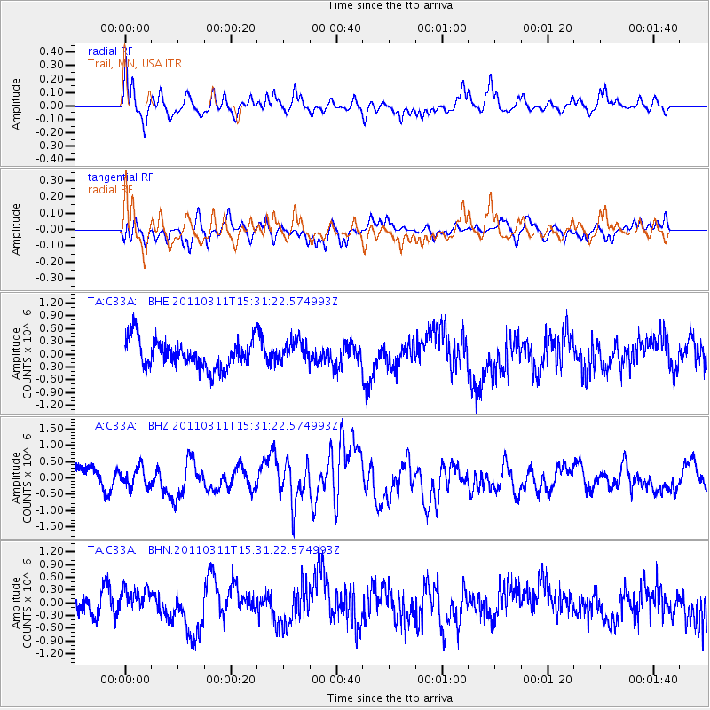
C33A Trail, MN, USA - Earthquake Result Viewer
*The percent match for this event was below the threshold and hence no stack was calculated.
| Earthquake location: |
Near East Coast Of Honshu, Japan |
| Earthquake latitude/longitude: |
36.2/141.9 |
| Earthquake time(UTC): |
2011/03/11 (070) 15:19:38 GMT |
| Earthquake Depth: |
35 km |
| Earthquake Magnitude: |
5.5 MB |
| Earthquake Catalog/Contributor: |
WHDF/NEIC |
|
| Network: |
TA USArray Transportable Network (new EarthScope stations) |
| Station: |
C33A Trail, MN, USA |
| Lat/Lon: |
47.76 N/95.77 W |
| Elevation: |
388 m |
|
| Distance: |
81.8 deg |
| Az: |
35.152 deg |
| Baz: |
316.388 deg |
| Ray Param: |
$rayparam |
*The percent match for this event was below the threshold and hence was not used in the summary stack. |
|
| Radial Match: |
42.123165 % |
| Radial Bump: |
304 |
| Transverse Match: |
50.83257 % |
| Transverse Bump: |
322 |
| SOD ConfigId: |
356183 |
| Insert Time: |
2011-08-17 05:24:04.769 +0000 |
| GWidth: |
2.5 |
| Max Bumps: |
400 |
| Tol: |
0.001 |
|
Signal To Noise
| Channel | StoN | STA | LTA |
| TA:C33A: :BHZ:20110311T15:31:22.574993Z | 0.84066856 | 3.3216682E-7 | 3.9512219E-7 |
| TA:C33A: :BHN:20110311T15:31:22.574993Z | 1.3927313 | 4.2895087E-7 | 3.0799256E-7 |
| TA:C33A: :BHE:20110311T15:31:22.574993Z | 0.75224864 | 2.480108E-7 | 3.296926E-7 |
| Arrivals |
| Ps | |
| PpPs | |
| PsPs/PpSs | |


