You are here: Home > Network List > US - United States National Seismic Network Stations List
> Station AGMN Agassiz National Wildlife Refuge, Minnesota, USA > Earthquake Result Viewer
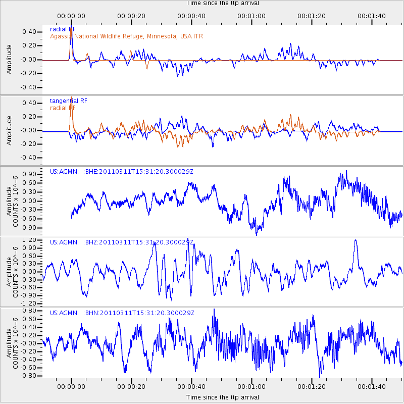
AGMN Agassiz National Wildlife Refuge, Minnesota, USA - Earthquake Result Viewer
*The percent match for this event was below the threshold and hence no stack was calculated.
| Earthquake location: |
Near East Coast Of Honshu, Japan |
| Earthquake latitude/longitude: |
36.2/141.9 |
| Earthquake time(UTC): |
2011/03/11 (070) 15:19:38 GMT |
| Earthquake Depth: |
35 km |
| Earthquake Magnitude: |
5.5 MB |
| Earthquake Catalog/Contributor: |
WHDF/NEIC |
|
| Network: |
US United States National Seismic Network |
| Station: |
AGMN Agassiz National Wildlife Refuge, Minnesota, USA |
| Lat/Lon: |
48.30 N/95.86 W |
| Elevation: |
351 m |
|
| Distance: |
81.4 deg |
| Az: |
34.819 deg |
| Baz: |
316.273 deg |
| Ray Param: |
$rayparam |
*The percent match for this event was below the threshold and hence was not used in the summary stack. |
|
| Radial Match: |
51.020508 % |
| Radial Bump: |
235 |
| Transverse Match: |
62.15882 % |
| Transverse Bump: |
331 |
| SOD ConfigId: |
356183 |
| Insert Time: |
2011-08-17 05:47:54.401 +0000 |
| GWidth: |
2.5 |
| Max Bumps: |
400 |
| Tol: |
0.001 |
|
Signal To Noise
| Channel | StoN | STA | LTA |
| US:AGMN: :BHZ:20110311T15:31:20.300029Z | 1.3571144 | 4.835519E-7 | 3.5630887E-7 |
| US:AGMN: :BHN:20110311T15:31:20.300029Z | 1.490317 | 4.1902274E-7 | 2.8116352E-7 |
| US:AGMN: :BHE:20110311T15:31:20.300029Z | 1.1401094 | 2.0685346E-7 | 1.8143298E-7 |
| Arrivals |
| Ps | |
| PpPs | |
| PsPs/PpSs | |


