You are here: Home > Network List > II - Global Seismograph Network (GSN - IRIS/IDA) Stations List
> Station WRAB Tennant Creek, NT, Australia > Earthquake Result Viewer
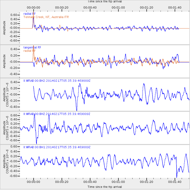
WRAB Tennant Creek, NT, Australia - Earthquake Result Viewer
*The percent match for this event was below the threshold and hence no stack was calculated.
| Earthquake location: |
Tonga Islands Region |
| Earthquake latitude/longitude: |
-22.4/-174.9 |
| Earthquake time(UTC): |
2014/02/17 (048) 05:27:40 GMT |
| Earthquake Depth: |
31 km |
| Earthquake Magnitude: |
5.4 MW |
| Earthquake Catalog/Contributor: |
ISC/ISC |
|
| Network: |
II Global Seismograph Network (GSN - IRIS/IDA) |
| Station: |
WRAB Tennant Creek, NT, Australia |
| Lat/Lon: |
19.93 S/134.36 E |
| Elevation: |
366 m |
|
| Distance: |
47.2 deg |
| Az: |
263.153 deg |
| Baz: |
102.475 deg |
| Ray Param: |
$rayparam |
*The percent match for this event was below the threshold and hence was not used in the summary stack. |
|
| Radial Match: |
65.05948 % |
| Radial Bump: |
400 |
| Transverse Match: |
64.739 % |
| Transverse Bump: |
400 |
| SOD ConfigId: |
3390531 |
| Insert Time: |
2019-04-10 08:45:02.336 +0000 |
| GWidth: |
2.5 |
| Max Bumps: |
400 |
| Tol: |
0.001 |
|
Signal To Noise
| Channel | StoN | STA | LTA |
| II:WRAB:00:BHZ:20140217T05:35:39.469009Z | 2.9450607 | 3.694161E-7 | 1.2543582E-7 |
| II:WRAB:00:BH1:20140217T05:35:39.469009Z | 1.0145109 | 1.08990996E-7 | 1.07432065E-7 |
| II:WRAB:00:BH2:20140217T05:35:39.469009Z | 2.6194036 | 2.5309714E-7 | 9.662396E-8 |
| Arrivals |
| Ps | |
| PpPs | |
| PsPs/PpSs | |


