You are here: Home > Network List > NE - New England Seismic Network Stations List
> Station QUA2 Belchertown, MA > Earthquake Result Viewer
QUA2 Belchertown, MA - Earthquake Result Viewer
| Earthquake location: |
Near East Coast Of Honshu, Japan |
| Earthquake latitude/longitude: |
36.4/141.9 |
| Earthquake time(UTC): |
2011/03/11 (070) 15:20:08 GMT |
| Earthquake Depth: |
53 km |
| Earthquake Magnitude: |
6.0 MB |
| Earthquake Catalog/Contributor: |
WHDF/NEIC |
|
| Network: |
NE New England Seismic Network |
| Station: |
QUA2 Belchertown, MA |
| Lat/Lon: |
42.28 N/72.35 W |
| Elevation: |
175 m |
|
| Distance: |
95.7 deg |
| Az: |
24.795 deg |
| Baz: |
332.875 deg |
| Ray Param: |
0.04068507 |
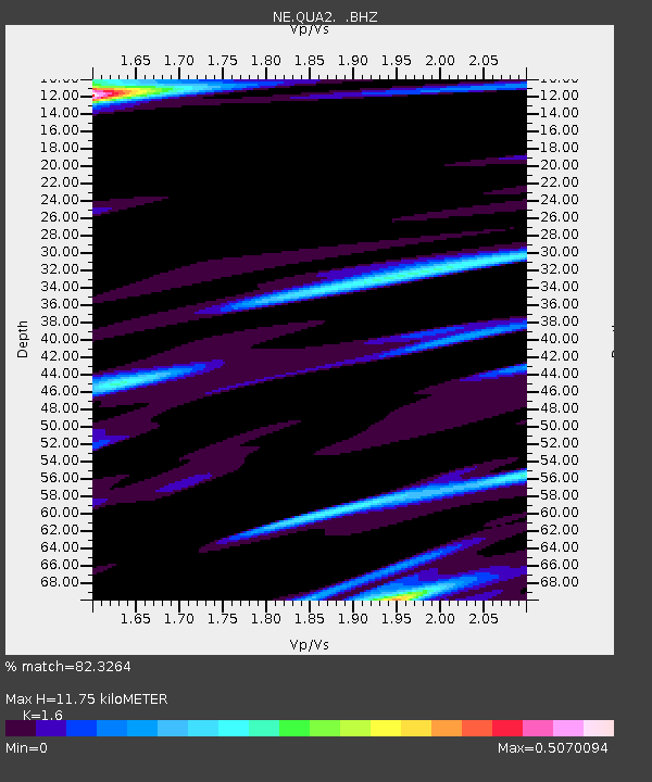
| Estimated Moho Depth: |
11.75 km |
| Estimated Crust Vp/Vs: |
1.60 |
| Assumed Crust Vp: |
6.419 km/s |
| Estimated Crust Vs: |
4.012 km/s |
| Estimated Crust Poisson's Ratio: |
0.18 |
|
| Radial Match: |
82.3264 % |
| Radial Bump: |
400 |
| Transverse Match: |
66.6151 % |
| Transverse Bump: |
400 |
| SOD ConfigId: |
356183 |
| Insert Time: |
2011-08-17 06:45:05.261 +0000 |
| GWidth: |
2.5 |
| Max Bumps: |
400 |
| Tol: |
0.001 |
|

Signal To Noise
| Channel | StoN | STA | LTA |
| NE:QUA2: :BHZ:20110311T15:32:56.820005Z | 1.19195 | 8.142491E-7 | 6.831236E-7 |
| NE:QUA2: :BHN:20110311T15:32:56.820005Z | 0.7989746 | 3.9296972E-7 | 4.918426E-7 |
| NE:QUA2: :BHE:20110311T15:32:56.820005Z | 1.4882866 | 7.7218647E-7 | 5.1884257E-7 |
| Arrivals |
| Ps | 1.1 SECOND |
| PpPs | 4.7 SECOND |
| PsPs/PpSs | 5.8 SECOND |


