You are here: Home > Network List > TA - USArray Transportable Network (new EarthScope stations) Stations List
> Station Q24A Divide, CO, USA > Earthquake Result Viewer
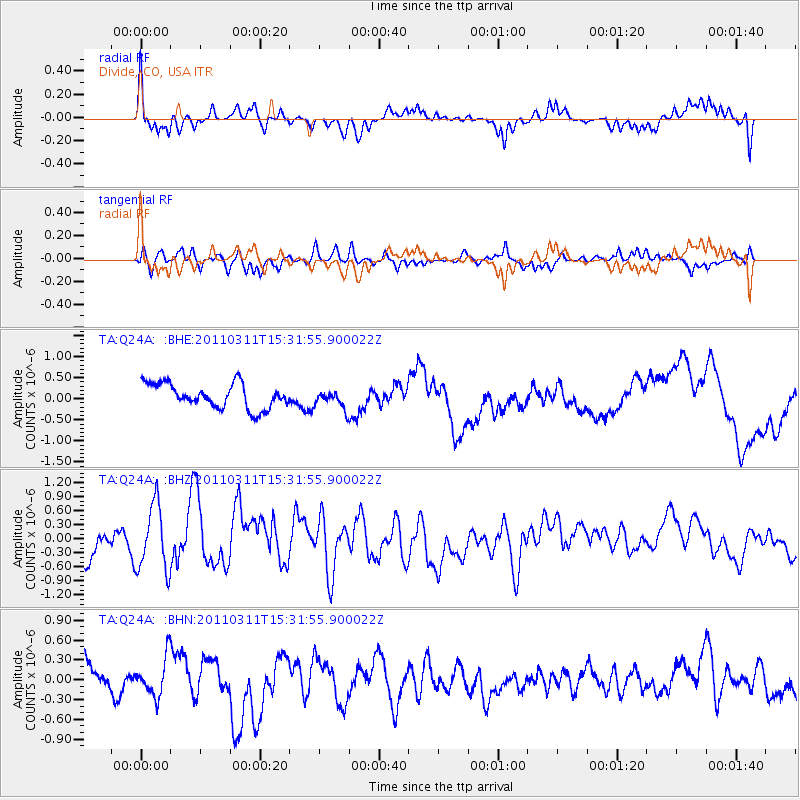
Q24A Divide, CO, USA - Earthquake Result Viewer
*The percent match for this event was below the threshold and hence no stack was calculated.
| Earthquake location: |
Near East Coast Of Honshu, Japan |
| Earthquake latitude/longitude: |
36.4/141.9 |
| Earthquake time(UTC): |
2011/03/11 (070) 15:20:08 GMT |
| Earthquake Depth: |
53 km |
| Earthquake Magnitude: |
6.0 MB |
| Earthquake Catalog/Contributor: |
WHDF/NEIC |
|
| Network: |
TA USArray Transportable Network (new EarthScope stations) |
| Station: |
Q24A Divide, CO, USA |
| Lat/Lon: |
38.96 N/105.15 W |
| Elevation: |
2775 m |
|
| Distance: |
82.9 deg |
| Az: |
46.329 deg |
| Baz: |
311.534 deg |
| Ray Param: |
$rayparam |
*The percent match for this event was below the threshold and hence was not used in the summary stack. |
|
| Radial Match: |
54.04255 % |
| Radial Bump: |
350 |
| Transverse Match: |
38.956947 % |
| Transverse Bump: |
352 |
| SOD ConfigId: |
356183 |
| Insert Time: |
2011-08-17 06:51:03.538 +0000 |
| GWidth: |
2.5 |
| Max Bumps: |
400 |
| Tol: |
0.001 |
|
Signal To Noise
| Channel | StoN | STA | LTA |
| TA:Q24A: :BHZ:20110311T15:31:55.900022Z | 1.8745246 | 7.273617E-7 | 3.880246E-7 |
| TA:Q24A: :BHN:20110311T15:31:55.900022Z | 1.4361145 | 2.933531E-7 | 2.0426859E-7 |
| TA:Q24A: :BHE:20110311T15:31:55.900022Z | 0.7544016 | 2.1912582E-7 | 2.9046308E-7 |
| Arrivals |
| Ps | |
| PpPs | |
| PsPs/PpSs | |


