You are here: Home > Network List > WY - Yellowstone Wyoming Seismic Network Stations List
> Station YHH Holmes Hill, YNP, WY, USA > Earthquake Result Viewer
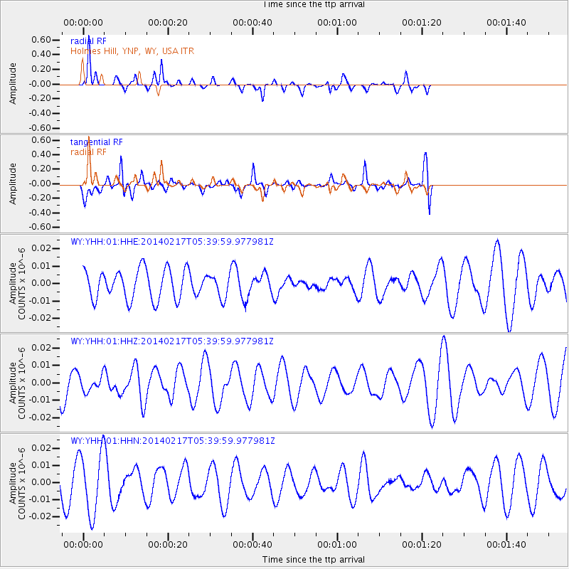
YHH Holmes Hill, YNP, WY, USA - Earthquake Result Viewer
*The percent match for this event was below the threshold and hence no stack was calculated.
| Earthquake location: |
Tonga Islands Region |
| Earthquake latitude/longitude: |
-22.4/-174.9 |
| Earthquake time(UTC): |
2014/02/17 (048) 05:27:40 GMT |
| Earthquake Depth: |
31 km |
| Earthquake Magnitude: |
5.4 MW |
| Earthquake Catalog/Contributor: |
ISC/ISC |
|
| Network: |
WY Yellowstone Wyoming Seismic Network |
| Station: |
YHH Holmes Hill, YNP, WY, USA |
| Lat/Lon: |
44.79 N/110.85 W |
| Elevation: |
2717 m |
|
| Distance: |
88.8 deg |
| Az: |
39.841 deg |
| Baz: |
236.348 deg |
| Ray Param: |
$rayparam |
*The percent match for this event was below the threshold and hence was not used in the summary stack. |
|
| Radial Match: |
61.49277 % |
| Radial Bump: |
231 |
| Transverse Match: |
57.749424 % |
| Transverse Bump: |
400 |
| SOD ConfigId: |
3390531 |
| Insert Time: |
2019-04-10 08:46:43.264 +0000 |
| GWidth: |
2.5 |
| Max Bumps: |
400 |
| Tol: |
0.001 |
|
Signal To Noise
| Channel | StoN | STA | LTA |
| WY:YHH:01:HHZ:20140217T05:39:59.977981Z | 0.406928 | 4.2762447E-9 | 1.0508603E-8 |
| WY:YHH:01:HHN:20140217T05:39:59.977981Z | 2.4894192 | 1.80703E-8 | 7.2588424E-9 |
| WY:YHH:01:HHE:20140217T05:39:59.977981Z | 0.77719176 | 6.730048E-9 | 8.659443E-9 |
| Arrivals |
| Ps | |
| PpPs | |
| PsPs/PpSs | |


