You are here: Home > Network List > TA - USArray Transportable Network (new EarthScope stations) Stations List
> Station J28A Allard Ranch, Norris, SD, USA > Earthquake Result Viewer
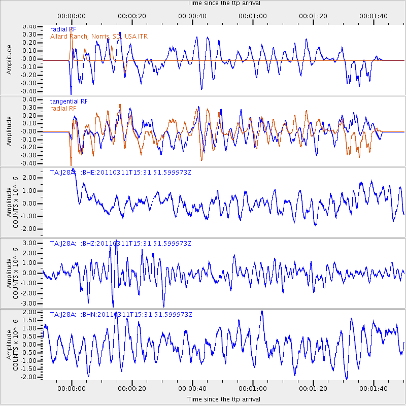
J28A Allard Ranch, Norris, SD, USA - Earthquake Result Viewer
*The percent match for this event was below the threshold and hence no stack was calculated.
| Earthquake location: |
Near East Coast Of Honshu, Japan |
| Earthquake latitude/longitude: |
36.4/141.9 |
| Earthquake time(UTC): |
2011/03/11 (070) 15:20:08 GMT |
| Earthquake Depth: |
53 km |
| Earthquake Magnitude: |
6.0 MB |
| Earthquake Catalog/Contributor: |
WHDF/NEIC |
|
| Network: |
TA USArray Transportable Network (new EarthScope stations) |
| Station: |
J28A Allard Ranch, Norris, SD, USA |
| Lat/Lon: |
43.42 N/101.24 W |
| Elevation: |
835 m |
|
| Distance: |
82.0 deg |
| Az: |
41.003 deg |
| Baz: |
313.403 deg |
| Ray Param: |
$rayparam |
*The percent match for this event was below the threshold and hence was not used in the summary stack. |
|
| Radial Match: |
58.964874 % |
| Radial Bump: |
400 |
| Transverse Match: |
55.61602 % |
| Transverse Bump: |
400 |
| SOD ConfigId: |
356183 |
| Insert Time: |
2011-08-17 06:56:55.366 +0000 |
| GWidth: |
2.5 |
| Max Bumps: |
400 |
| Tol: |
0.001 |
|
Signal To Noise
| Channel | StoN | STA | LTA |
| TA:J28A: :BHZ:20110311T15:31:51.599973Z | 1.6237656 | 9.195257E-7 | 5.662921E-7 |
| TA:J28A: :BHN:20110311T15:31:51.599973Z | 0.6471446 | 5.5157597E-7 | 8.5232256E-7 |
| TA:J28A: :BHE:20110311T15:31:51.599973Z | 0.67416674 | 5.464134E-7 | 8.105019E-7 |
| Arrivals |
| Ps | |
| PpPs | |
| PsPs/PpSs | |


