You are here: Home > Network List > TA - USArray Transportable Network (new EarthScope stations) Stations List
> Station H28A Mission Ridge, SD, USA > Earthquake Result Viewer
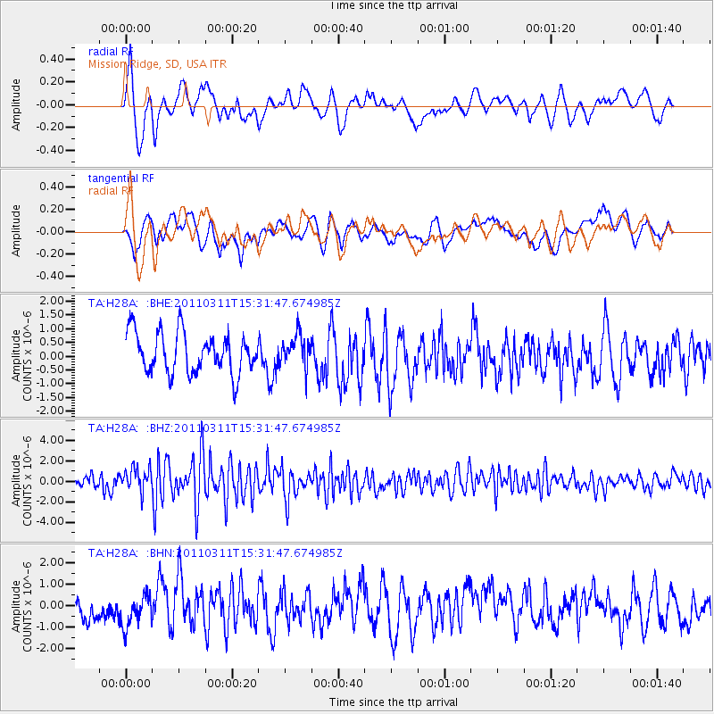
H28A Mission Ridge, SD, USA - Earthquake Result Viewer
*The percent match for this event was below the threshold and hence no stack was calculated.
| Earthquake location: |
Near East Coast Of Honshu, Japan |
| Earthquake latitude/longitude: |
36.4/141.9 |
| Earthquake time(UTC): |
2011/03/11 (070) 15:20:08 GMT |
| Earthquake Depth: |
53 km |
| Earthquake Magnitude: |
6.0 MB |
| Earthquake Catalog/Contributor: |
WHDF/NEIC |
|
| Network: |
TA USArray Transportable Network (new EarthScope stations) |
| Station: |
H28A Mission Ridge, SD, USA |
| Lat/Lon: |
44.68 N/101.02 W |
| Elevation: |
642 m |
|
| Distance: |
81.3 deg |
| Az: |
39.976 deg |
| Baz: |
313.403 deg |
| Ray Param: |
$rayparam |
*The percent match for this event was below the threshold and hence was not used in the summary stack. |
|
| Radial Match: |
75.23959 % |
| Radial Bump: |
400 |
| Transverse Match: |
59.81848 % |
| Transverse Bump: |
400 |
| SOD ConfigId: |
356183 |
| Insert Time: |
2011-08-17 06:58:35.077 +0000 |
| GWidth: |
2.5 |
| Max Bumps: |
400 |
| Tol: |
0.001 |
|
Signal To Noise
| Channel | StoN | STA | LTA |
| TA:H28A: :BHZ:20110311T15:31:47.674985Z | 1.8714441 | 1.1912059E-6 | 6.36517E-7 |
| TA:H28A: :BHN:20110311T15:31:47.674985Z | 1.1704726 | 7.7438943E-7 | 6.616041E-7 |
| TA:H28A: :BHE:20110311T15:31:47.674985Z | 0.7796952 | 5.727198E-7 | 7.345432E-7 |
| Arrivals |
| Ps | |
| PpPs | |
| PsPs/PpSs | |


