You are here: Home > Network List > TA - USArray Transportable Network (new EarthScope stations) Stations List
> Station X33A Lawton, OK, USA > Earthquake Result Viewer
X33A Lawton, OK, USA - Earthquake Result Viewer
*The percent match for this event was below the threshold and hence no stack was calculated.
| Earthquake location: |
Near East Coast Of Honshu, Japan |
| Earthquake latitude/longitude: |
36.4/141.9 |
| Earthquake time(UTC): |
2011/03/11 (070) 15:20:08 GMT |
| Earthquake Depth: |
53 km |
| Earthquake Magnitude: |
6.0 MB |
| Earthquake Catalog/Contributor: |
WHDF/NEIC |
|
| Network: |
TA USArray Transportable Network (new EarthScope stations) |
| Station: |
X33A Lawton, OK, USA |
| Lat/Lon: |
34.54 N/98.50 W |
| Elevation: |
346 m |
|
| Distance: |
89.8 deg |
| Az: |
45.85 deg |
| Baz: |
315.47 deg |
| Ray Param: |
$rayparam |
*The percent match for this event was below the threshold and hence was not used in the summary stack. |
|
| Radial Match: |
65.59099 % |
| Radial Bump: |
255 |
| Transverse Match: |
52.4756 % |
| Transverse Bump: |
367 |
| SOD ConfigId: |
356183 |
| Insert Time: |
2011-08-17 07:10:28.919 +0000 |
| GWidth: |
2.5 |
| Max Bumps: |
400 |
| Tol: |
0.001 |
|
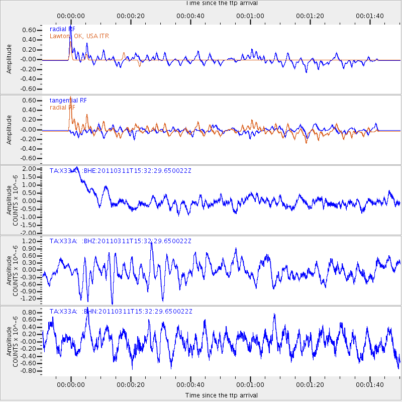
Signal To Noise
| Channel | StoN | STA | LTA |
| TA:X33A: :BHZ:20110311T15:32:29.650022Z | 1.5009695 | 6.0759106E-7 | 4.0479907E-7 |
| TA:X33A: :BHN:20110311T15:32:29.650022Z | 0.6597842 | 2.973379E-7 | 4.5065931E-7 |
| TA:X33A: :BHE:20110311T15:32:29.650022Z | 0.7259956 | 5.472395E-7 | 7.5377795E-7 |
| Arrivals |
| Ps | |
| PpPs | |
| PsPs/PpSs | |


