You are here: Home > Network List > TA - USArray Transportable Network (new EarthScope stations) Stations List
> Station V34A Guthrie, OK, USA > Earthquake Result Viewer
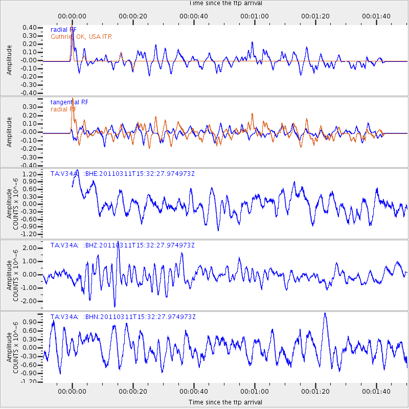
V34A Guthrie, OK, USA - Earthquake Result Viewer
*The percent match for this event was below the threshold and hence no stack was calculated.
| Earthquake location: |
Near East Coast Of Honshu, Japan |
| Earthquake latitude/longitude: |
36.4/141.9 |
| Earthquake time(UTC): |
2011/03/11 (070) 15:20:08 GMT |
| Earthquake Depth: |
53 km |
| Earthquake Magnitude: |
6.0 MB |
| Earthquake Catalog/Contributor: |
WHDF/NEIC |
|
| Network: |
TA USArray Transportable Network (new EarthScope stations) |
| Station: |
V34A Guthrie, OK, USA |
| Lat/Lon: |
35.83 N/97.52 W |
| Elevation: |
329 m |
|
| Distance: |
89.4 deg |
| Az: |
44.372 deg |
| Baz: |
316.024 deg |
| Ray Param: |
$rayparam |
*The percent match for this event was below the threshold and hence was not used in the summary stack. |
|
| Radial Match: |
63.426487 % |
| Radial Bump: |
381 |
| Transverse Match: |
50.255615 % |
| Transverse Bump: |
376 |
| SOD ConfigId: |
356183 |
| Insert Time: |
2011-08-17 07:12:15.836 +0000 |
| GWidth: |
2.5 |
| Max Bumps: |
400 |
| Tol: |
0.001 |
|
Signal To Noise
| Channel | StoN | STA | LTA |
| TA:V34A: :BHZ:20110311T15:32:27.974973Z | 1.5355284 | 7.829824E-7 | 5.099107E-7 |
| TA:V34A: :BHN:20110311T15:32:27.974973Z | 1.0195464 | 6.141123E-7 | 6.0233873E-7 |
| TA:V34A: :BHE:20110311T15:32:27.974973Z | 0.6008599 | 2.9197133E-7 | 4.8592256E-7 |
| Arrivals |
| Ps | |
| PpPs | |
| PsPs/PpSs | |


