You are here: Home > Network List > TA - USArray Transportable Network (new EarthScope stations) Stations List
> Station 333A Richland Springs, TX, USA > Earthquake Result Viewer
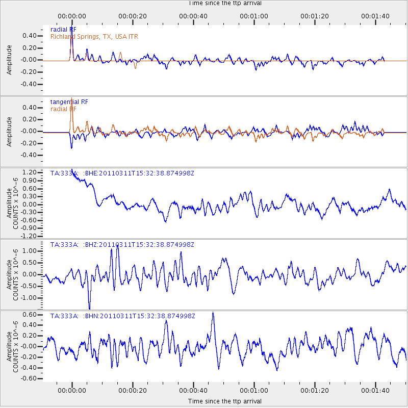
333A Richland Springs, TX, USA - Earthquake Result Viewer
*The percent match for this event was below the threshold and hence no stack was calculated.
| Earthquake location: |
Near East Coast Of Honshu, Japan |
| Earthquake latitude/longitude: |
36.4/141.9 |
| Earthquake time(UTC): |
2011/03/11 (070) 15:20:08 GMT |
| Earthquake Depth: |
53 km |
| Earthquake Magnitude: |
6.0 MB |
| Earthquake Catalog/Contributor: |
WHDF/NEIC |
|
| Network: |
TA USArray Transportable Network (new EarthScope stations) |
| Station: |
333A Richland Springs, TX, USA |
| Lat/Lon: |
31.32 N/98.98 W |
| Elevation: |
443 m |
|
| Distance: |
91.8 deg |
| Az: |
48.394 deg |
| Baz: |
315.175 deg |
| Ray Param: |
$rayparam |
*The percent match for this event was below the threshold and hence was not used in the summary stack. |
|
| Radial Match: |
54.81595 % |
| Radial Bump: |
283 |
| Transverse Match: |
38.9577 % |
| Transverse Bump: |
305 |
| SOD ConfigId: |
356183 |
| Insert Time: |
2011-08-17 07:15:25.610 +0000 |
| GWidth: |
2.5 |
| Max Bumps: |
400 |
| Tol: |
0.001 |
|
Signal To Noise
| Channel | StoN | STA | LTA |
| TA:333A: :BHZ:20110311T15:32:38.874998Z | 0.96536523 | 3.0809153E-7 | 3.1914504E-7 |
| TA:333A: :BHN:20110311T15:32:38.874998Z | 0.8873603 | 1.1147593E-7 | 1.2562646E-7 |
| TA:333A: :BHE:20110311T15:32:38.874998Z | 1.3561374 | 5.6764856E-7 | 4.1857749E-7 |
| Arrivals |
| Ps | |
| PpPs | |
| PsPs/PpSs | |


