You are here: Home > Network List > TA - USArray Transportable Network (new EarthScope stations) Stations List
> Station I32A Karley and Nick, Howard, SD, USA > Earthquake Result Viewer
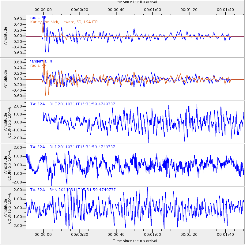
I32A Karley and Nick, Howard, SD, USA - Earthquake Result Viewer
*The percent match for this event was below the threshold and hence no stack was calculated.
| Earthquake location: |
Near East Coast Of Honshu, Japan |
| Earthquake latitude/longitude: |
36.4/141.9 |
| Earthquake time(UTC): |
2011/03/11 (070) 15:20:08 GMT |
| Earthquake Depth: |
53 km |
| Earthquake Magnitude: |
6.0 MB |
| Earthquake Catalog/Contributor: |
WHDF/NEIC |
|
| Network: |
TA USArray Transportable Network (new EarthScope stations) |
| Station: |
I32A Karley and Nick, Howard, SD, USA |
| Lat/Lon: |
44.03 N/97.46 W |
| Elevation: |
493 m |
|
| Distance: |
83.6 deg |
| Az: |
38.636 deg |
| Baz: |
315.704 deg |
| Ray Param: |
$rayparam |
*The percent match for this event was below the threshold and hence was not used in the summary stack. |
|
| Radial Match: |
70.741486 % |
| Radial Bump: |
400 |
| Transverse Match: |
64.1369 % |
| Transverse Bump: |
400 |
| SOD ConfigId: |
356183 |
| Insert Time: |
2011-08-17 07:34:42.201 +0000 |
| GWidth: |
2.5 |
| Max Bumps: |
400 |
| Tol: |
0.001 |
|
Signal To Noise
| Channel | StoN | STA | LTA |
| TA:I32A: :BHZ:20110311T15:31:59.474973Z | 1.3732306 | 9.852324E-7 | 7.174559E-7 |
| TA:I32A: :BHN:20110311T15:31:59.474973Z | 0.87596315 | 4.1312487E-7 | 4.7162357E-7 |
| TA:I32A: :BHE:20110311T15:31:59.474973Z | 1.2249483 | 6.0741274E-7 | 4.958681E-7 |
| Arrivals |
| Ps | |
| PpPs | |
| PsPs/PpSs | |


