You are here: Home > Network List > TA - USArray Transportable Network (new EarthScope stations) Stations List
> Station B32A Ashes, Strandquist, MN, USA > Earthquake Result Viewer
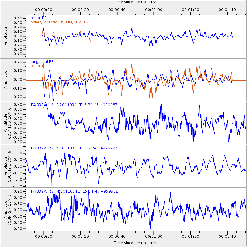
B32A Ashes, Strandquist, MN, USA - Earthquake Result Viewer
*The percent match for this event was below the threshold and hence no stack was calculated.
| Earthquake location: |
Near East Coast Of Honshu, Japan |
| Earthquake latitude/longitude: |
36.4/141.9 |
| Earthquake time(UTC): |
2011/03/11 (070) 15:20:08 GMT |
| Earthquake Depth: |
53 km |
| Earthquake Magnitude: |
6.0 MB |
| Earthquake Catalog/Contributor: |
WHDF/NEIC |
|
| Network: |
TA USArray Transportable Network (new EarthScope stations) |
| Station: |
B32A Ashes, Strandquist, MN, USA |
| Lat/Lon: |
48.40 N/96.54 W |
| Elevation: |
335 m |
|
| Distance: |
80.9 deg |
| Az: |
35.096 deg |
| Baz: |
315.893 deg |
| Ray Param: |
$rayparam |
*The percent match for this event was below the threshold and hence was not used in the summary stack. |
|
| Radial Match: |
43.48684 % |
| Radial Bump: |
250 |
| Transverse Match: |
48.212345 % |
| Transverse Bump: |
299 |
| SOD ConfigId: |
356183 |
| Insert Time: |
2011-08-17 07:42:04.585 +0000 |
| GWidth: |
2.5 |
| Max Bumps: |
400 |
| Tol: |
0.001 |
|
Signal To Noise
| Channel | StoN | STA | LTA |
| TA:B32A: :BHZ:20110311T15:31:45.499998Z | 1.5050694 | 6.3632706E-7 | 4.2278918E-7 |
| TA:B32A: :BHN:20110311T15:31:45.499998Z | 1.209827 | 5.2841176E-7 | 4.3676638E-7 |
| TA:B32A: :BHE:20110311T15:31:45.499998Z | 1.0487623 | 3.2706626E-7 | 3.118593E-7 |
| Arrivals |
| Ps | |
| PpPs | |
| PsPs/PpSs | |


