You are here: Home > Network List > TA - USArray Transportable Network (new EarthScope stations) Stations List
> Station E31A Nome, ND, USA > Earthquake Result Viewer
E31A Nome, ND, USA - Earthquake Result Viewer
| Earthquake location: |
Near East Coast Of Honshu, Japan |
| Earthquake latitude/longitude: |
36.4/141.9 |
| Earthquake time(UTC): |
2011/03/11 (070) 15:20:08 GMT |
| Earthquake Depth: |
53 km |
| Earthquake Magnitude: |
6.0 MB |
| Earthquake Catalog/Contributor: |
WHDF/NEIC |
|
| Network: |
TA USArray Transportable Network (new EarthScope stations) |
| Station: |
E31A Nome, ND, USA |
| Lat/Lon: |
46.56 N/97.89 W |
| Elevation: |
427 m |
|
| Distance: |
81.5 deg |
| Az: |
37.061 deg |
| Baz: |
315.2 deg |
| Ray Param: |
0.047419984 |
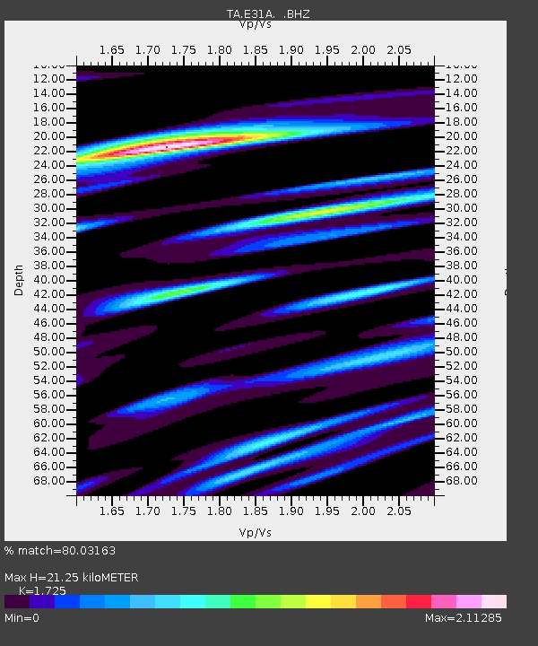
| Estimated Moho Depth: |
21.25 km |
| Estimated Crust Vp/Vs: |
1.73 |
| Assumed Crust Vp: |
6.498 km/s |
| Estimated Crust Vs: |
3.767 km/s |
| Estimated Crust Poisson's Ratio: |
0.25 |
|
| Radial Match: |
80.03163 % |
| Radial Bump: |
357 |
| Transverse Match: |
67.08303 % |
| Transverse Bump: |
400 |
| SOD ConfigId: |
356183 |
| Insert Time: |
2011-08-17 07:42:36.514 +0000 |
| GWidth: |
2.5 |
| Max Bumps: |
400 |
| Tol: |
0.001 |
|
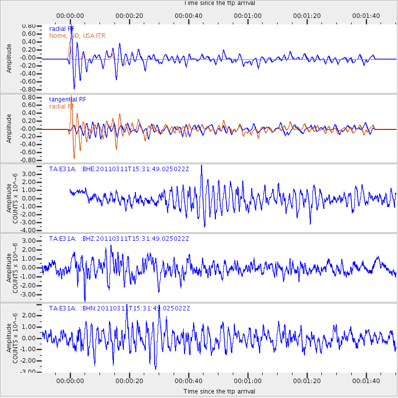
Signal To Noise
| Channel | StoN | STA | LTA |
| TA:E31A: :BHZ:20110311T15:31:49.025022Z | 2.0810323 | 1.0933436E-6 | 5.2538525E-7 |
| TA:E31A: :BHN:20110311T15:31:49.025022Z | 1.1954829 | 5.416721E-7 | 4.5309898E-7 |
| TA:E31A: :BHE:20110311T15:31:49.025022Z | 1.2762 | 7.3439224E-7 | 5.7545225E-7 |
| Arrivals |
| Ps | 2.4 SECOND |
| PpPs | 8.7 SECOND |
| PsPs/PpSs | 11 SECOND |


