You are here: Home > Network List > TA - USArray Transportable Network (new EarthScope stations) Stations List
> Station M36A Felix, Anita, IA, USA > Earthquake Result Viewer
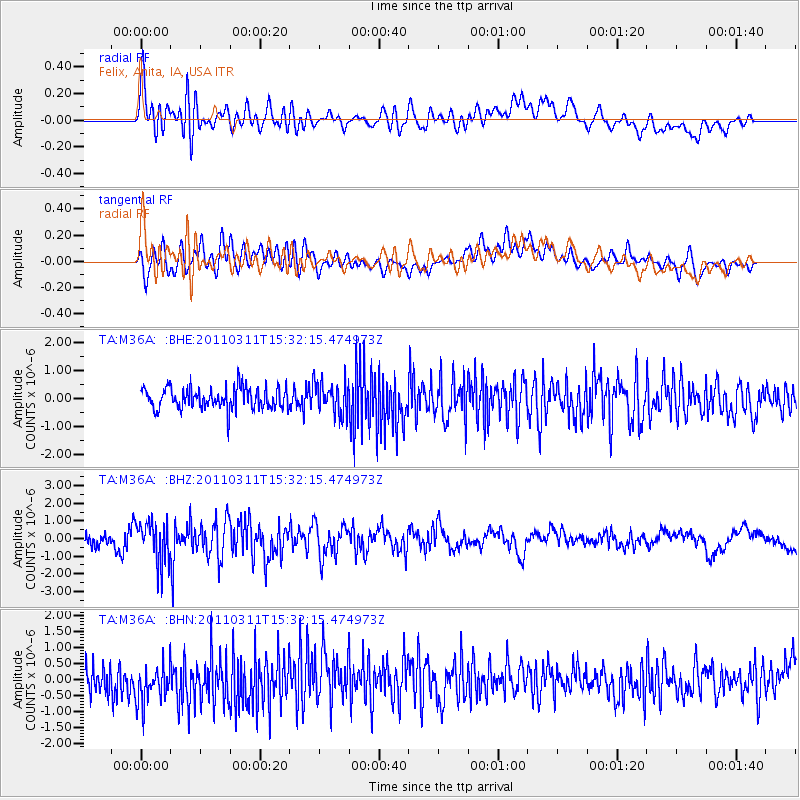
M36A Felix, Anita, IA, USA - Earthquake Result Viewer
*The percent match for this event was below the threshold and hence no stack was calculated.
| Earthquake location: |
Near East Coast Of Honshu, Japan |
| Earthquake latitude/longitude: |
36.4/141.9 |
| Earthquake time(UTC): |
2011/03/11 (070) 15:20:08 GMT |
| Earthquake Depth: |
53 km |
| Earthquake Magnitude: |
6.0 MB |
| Earthquake Catalog/Contributor: |
WHDF/NEIC |
|
| Network: |
TA USArray Transportable Network (new EarthScope stations) |
| Station: |
M36A Felix, Anita, IA, USA |
| Lat/Lon: |
41.45 N/94.80 W |
| Elevation: |
430 m |
|
| Distance: |
86.8 deg |
| Az: |
38.978 deg |
| Baz: |
317.534 deg |
| Ray Param: |
$rayparam |
*The percent match for this event was below the threshold and hence was not used in the summary stack. |
|
| Radial Match: |
71.57811 % |
| Radial Bump: |
400 |
| Transverse Match: |
64.456825 % |
| Transverse Bump: |
400 |
| SOD ConfigId: |
356183 |
| Insert Time: |
2011-08-17 07:58:34.579 +0000 |
| GWidth: |
2.5 |
| Max Bumps: |
400 |
| Tol: |
0.001 |
|
Signal To Noise
| Channel | StoN | STA | LTA |
| TA:M36A: :BHZ:20110311T15:32:15.474973Z | 2.302298 | 1.1841743E-6 | 5.1434444E-7 |
| TA:M36A: :BHN:20110311T15:32:15.474973Z | 1.3253417 | 7.547631E-7 | 5.694857E-7 |
| TA:M36A: :BHE:20110311T15:32:15.474973Z | 1.5185574 | 5.7051386E-7 | 3.7569464E-7 |
| Arrivals |
| Ps | |
| PpPs | |
| PsPs/PpSs | |


