You are here: Home > Network List > TA - USArray Transportable Network (new EarthScope stations) Stations List
> Station S39A Bolivar, MO, USA > Earthquake Result Viewer
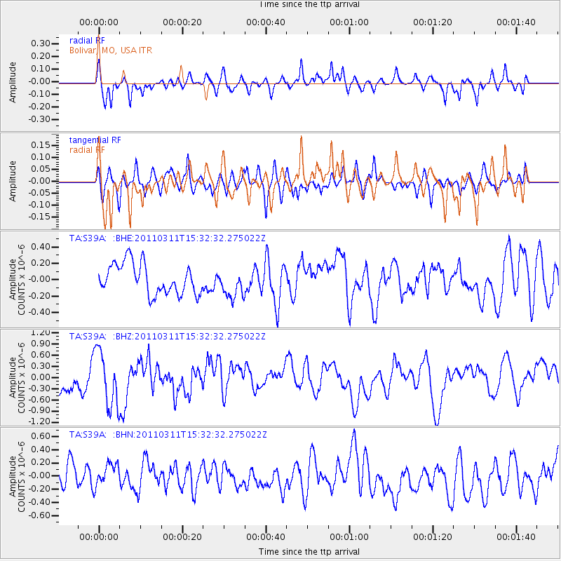
S39A Bolivar, MO, USA - Earthquake Result Viewer
*The percent match for this event was below the threshold and hence no stack was calculated.
| Earthquake location: |
Near East Coast Of Honshu, Japan |
| Earthquake latitude/longitude: |
36.4/141.9 |
| Earthquake time(UTC): |
2011/03/11 (070) 15:20:08 GMT |
| Earthquake Depth: |
53 km |
| Earthquake Magnitude: |
6.0 MB |
| Earthquake Catalog/Contributor: |
WHDF/NEIC |
|
| Network: |
TA USArray Transportable Network (new EarthScope stations) |
| Station: |
S39A Bolivar, MO, USA |
| Lat/Lon: |
37.69 N/93.32 W |
| Elevation: |
331 m |
|
| Distance: |
90.3 deg |
| Az: |
40.641 deg |
| Baz: |
318.516 deg |
| Ray Param: |
$rayparam |
*The percent match for this event was below the threshold and hence was not used in the summary stack. |
|
| Radial Match: |
46.214626 % |
| Radial Bump: |
311 |
| Transverse Match: |
53.77476 % |
| Transverse Bump: |
336 |
| SOD ConfigId: |
356183 |
| Insert Time: |
2011-08-17 08:04:52.056 +0000 |
| GWidth: |
2.5 |
| Max Bumps: |
400 |
| Tol: |
0.001 |
|
Signal To Noise
| Channel | StoN | STA | LTA |
| TA:S39A: :BHZ:20110311T15:32:32.275022Z | 2.0226188 | 7.58052E-7 | 3.747874E-7 |
| TA:S39A: :BHN:20110311T15:32:32.275022Z | 0.844354 | 1.6682462E-7 | 1.9757664E-7 |
| TA:S39A: :BHE:20110311T15:32:32.275022Z | 0.94624 | 1.7584799E-7 | 1.8583867E-7 |
| Arrivals |
| Ps | |
| PpPs | |
| PsPs/PpSs | |


