You are here: Home > Network List > US - United States National Seismic Network Stations List
> Station WMOK Wichita Mountains, Oklahoma, USA > Earthquake Result Viewer
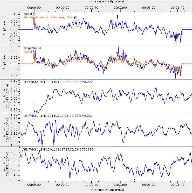
WMOK Wichita Mountains, Oklahoma, USA - Earthquake Result Viewer
*The percent match for this event was below the threshold and hence no stack was calculated.
| Earthquake location: |
Near East Coast Of Honshu, Japan |
| Earthquake latitude/longitude: |
36.4/141.9 |
| Earthquake time(UTC): |
2011/03/11 (070) 15:20:08 GMT |
| Earthquake Depth: |
53 km |
| Earthquake Magnitude: |
6.0 MB |
| Earthquake Catalog/Contributor: |
WHDF/NEIC |
|
| Network: |
US United States National Seismic Network |
| Station: |
WMOK Wichita Mountains, Oklahoma, USA |
| Lat/Lon: |
34.74 N/98.78 W |
| Elevation: |
486 m |
|
| Distance: |
89.5 deg |
| Az: |
45.876 deg |
| Baz: |
315.312 deg |
| Ray Param: |
$rayparam |
*The percent match for this event was below the threshold and hence was not used in the summary stack. |
|
| Radial Match: |
42.881203 % |
| Radial Bump: |
302 |
| Transverse Match: |
42.3616 % |
| Transverse Bump: |
310 |
| SOD ConfigId: |
356183 |
| Insert Time: |
2011-08-17 08:13:58.821 +0000 |
| GWidth: |
2.5 |
| Max Bumps: |
400 |
| Tol: |
0.001 |
|
Signal To Noise
| Channel | StoN | STA | LTA |
| US:WMOK: :BHZ:20110311T15:32:28.275022Z | 1.5887538 | 4.615266E-7 | 2.90496E-7 |
| US:WMOK: :BHN:20110311T15:32:28.275022Z | 0.7803985 | 1.3626715E-6 | 1.7461226E-6 |
| US:WMOK: :BHE:20110311T15:32:28.275022Z | 0.41953415 | 1.785754E-7 | 4.2565168E-7 |
| Arrivals |
| Ps | |
| PpPs | |
| PsPs/PpSs | |


