You are here: Home > Network List > AZ - ANZA Regional Network Stations List
> Station SMER AZ.SMER > Earthquake Result Viewer
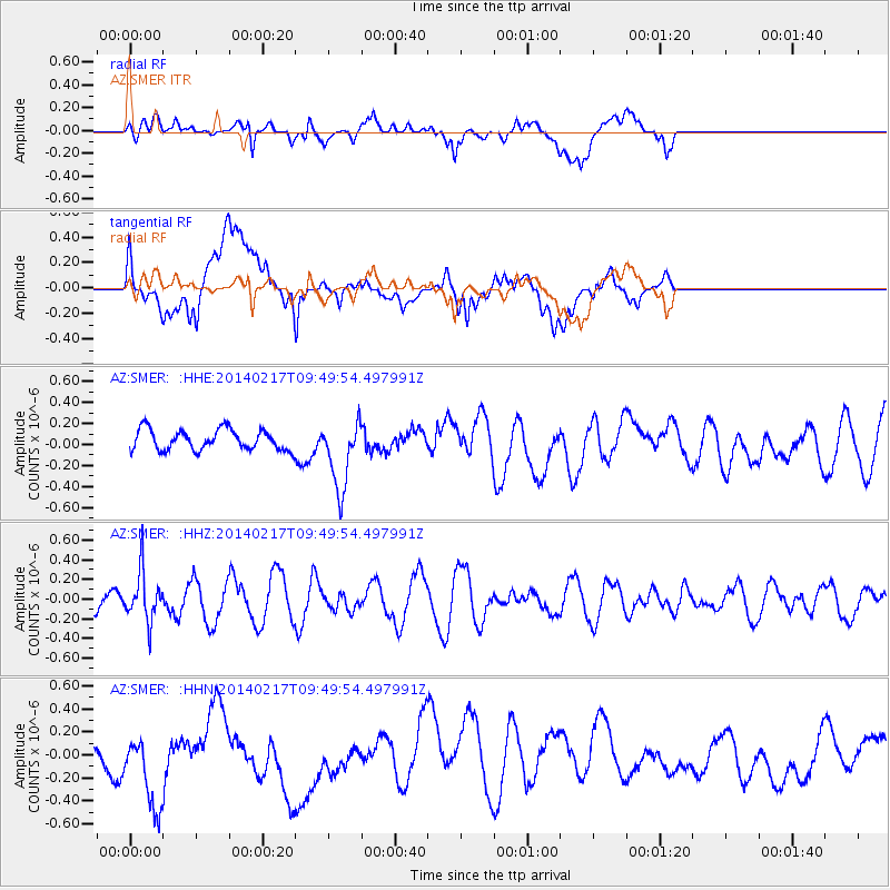
SMER AZ.SMER - Earthquake Result Viewer
*The percent match for this event was below the threshold and hence no stack was calculated.
| Earthquake location: |
Northern Colombia |
| Earthquake latitude/longitude: |
6.5/-71.7 |
| Earthquake time(UTC): |
2014/02/17 (048) 09:41:35 GMT |
| Earthquake Depth: |
41 km |
| Earthquake Magnitude: |
5.3 MW |
| Earthquake Catalog/Contributor: |
ISC/ISC |
|
| Network: |
AZ ANZA Regional Network |
| Station: |
SMER AZ.SMER |
| Lat/Lon: |
33.46 N/117.17 W |
| Elevation: |
355 m |
|
| Distance: |
49.9 deg |
| Az: |
308.788 deg |
| Baz: |
112.119 deg |
| Ray Param: |
$rayparam |
*The percent match for this event was below the threshold and hence was not used in the summary stack. |
|
| Radial Match: |
40.307068 % |
| Radial Bump: |
400 |
| Transverse Match: |
43.93477 % |
| Transverse Bump: |
400 |
| SOD ConfigId: |
3390531 |
| Insert Time: |
2019-04-10 08:51:25.254 +0000 |
| GWidth: |
2.5 |
| Max Bumps: |
400 |
| Tol: |
0.001 |
|
Signal To Noise
| Channel | StoN | STA | LTA |
| AZ:SMER: :HHZ:20140217T09:49:54.497991Z | 0.7765351 | 2.4920797E-7 | 3.20923E-7 |
| AZ:SMER: :HHN:20140217T09:49:54.497991Z | 3.9891024 | 3.9017985E-7 | 9.781144E-8 |
| AZ:SMER: :HHE:20140217T09:49:54.497991Z | 3.3704743 | 3.2857173E-7 | 9.7485305E-8 |
| Arrivals |
| Ps | |
| PpPs | |
| PsPs/PpSs | |


