You are here: Home > Network List > TA - USArray Transportable Network (new EarthScope stations) Stations List
> Station ABTX Abilene, Hawley, TX, USA > Earthquake Result Viewer
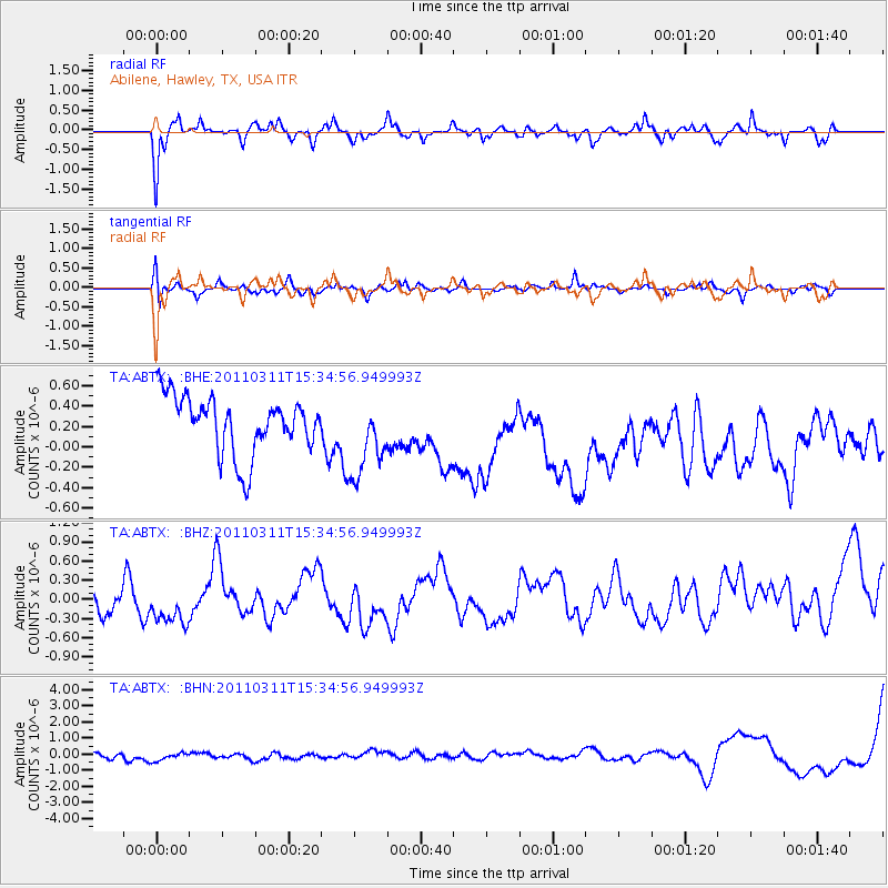
ABTX Abilene, Hawley, TX, USA - Earthquake Result Viewer
*The percent match for this event was below the threshold and hence no stack was calculated.
| Earthquake location: |
Near East Coast Of Honshu, Japan |
| Earthquake latitude/longitude: |
35.6/141.5 |
| Earthquake time(UTC): |
2011/03/11 (070) 15:22:27 GMT |
| Earthquake Depth: |
35 km |
| Earthquake Magnitude: |
5.5 MB |
| Earthquake Catalog/Contributor: |
WHDF/NEIC |
|
| Network: |
TA USArray Transportable Network (new EarthScope stations) |
| Station: |
ABTX Abilene, Hawley, TX, USA |
| Lat/Lon: |
32.62 N/99.64 W |
| Elevation: |
502 m |
|
| Distance: |
91.1 deg |
| Az: |
47.695 deg |
| Baz: |
314.447 deg |
| Ray Param: |
$rayparam |
*The percent match for this event was below the threshold and hence was not used in the summary stack. |
|
| Radial Match: |
61.51655 % |
| Radial Bump: |
314 |
| Transverse Match: |
52.83717 % |
| Transverse Bump: |
400 |
| SOD ConfigId: |
356183 |
| Insert Time: |
2011-08-17 09:24:17.224 +0000 |
| GWidth: |
2.5 |
| Max Bumps: |
400 |
| Tol: |
0.001 |
|
Signal To Noise
| Channel | StoN | STA | LTA |
| TA:ABTX: :BHZ:20110311T15:34:56.949993Z | 0.8655106 | 3.389562E-7 | 3.916257E-7 |
| TA:ABTX: :BHN:20110311T15:34:56.949993Z | 1.4598664 | 3.5748954E-7 | 2.4487827E-7 |
| TA:ABTX: :BHE:20110311T15:34:56.949993Z | 1.4061728 | 3.9442867E-7 | 2.8049803E-7 |
| Arrivals |
| Ps | |
| PpPs | |
| PsPs/PpSs | |


