You are here: Home > Network List > AZ - ANZA Regional Network Stations List
> Station PFO AZ.PFO > Earthquake Result Viewer
PFO AZ.PFO - Earthquake Result Viewer
| Earthquake location: |
Peru-Ecuador Border Region |
| Earthquake latitude/longitude: |
-2.3/-77.8 |
| Earthquake time(UTC): |
2007/11/16 (320) 03:13:00 GMT |
| Earthquake Depth: |
123 km |
| Earthquake Magnitude: |
6.3 MB, 6.8 MW, 6.7 MW |
| Earthquake Catalog/Contributor: |
WHDF/NEIC |
|
| Network: |
AZ ANZA Regional Network |
| Station: |
PFO AZ.PFO |
| Lat/Lon: |
33.61 N/116.46 W |
| Elevation: |
1259 m |
|
| Distance: |
51.0 deg |
| Az: |
317.91 deg |
| Baz: |
126.623 deg |
| Ray Param: |
0.06729306 |
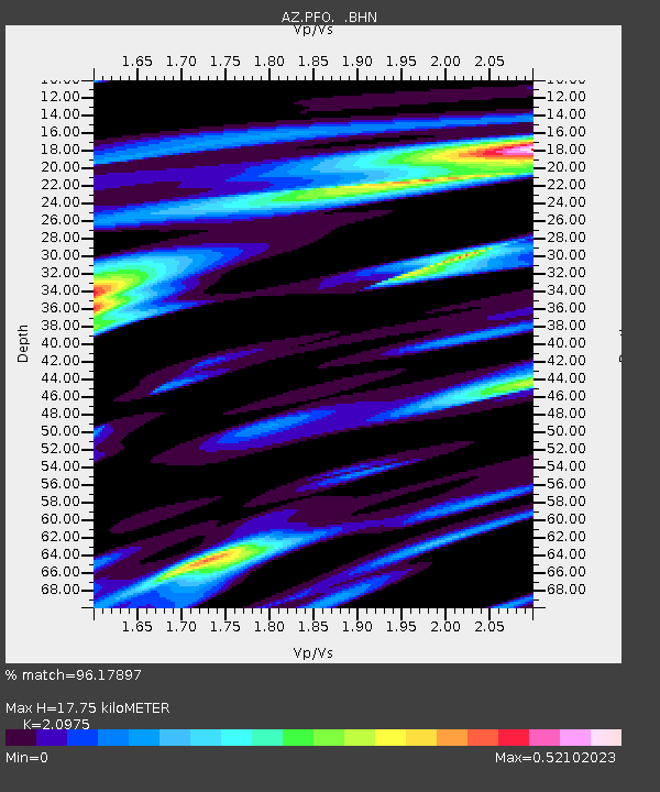
| Estimated Moho Depth: |
17.75 km |
| Estimated Crust Vp/Vs: |
2.10 |
| Assumed Crust Vp: |
6.264 km/s |
| Estimated Crust Vs: |
2.986 km/s |
| Estimated Crust Poisson's Ratio: |
0.35 |
|
| Radial Match: |
96.17897 % |
| Radial Bump: |
400 |
| Transverse Match: |
79.17496 % |
| Transverse Bump: |
400 |
| SOD ConfigId: |
2564 |
| Insert Time: |
2010-02-26 20:13:56.335 +0000 |
| GWidth: |
2.5 |
| Max Bumps: |
400 |
| Tol: |
0.001 |
|

Signal To Noise
| Channel | StoN | STA | LTA |
| AZ:PFO: :BHN:20071116T03:21:18.798009Z | 2.3753376 | 5.037067E-7 | 2.1205689E-7 |
| AZ:PFO: :BHE:20071116T03:21:18.798009Z | 6.619018 | 7.797207E-7 | 1.17800056E-7 |
| AZ:PFO: :BHZ:20071116T03:21:18.798009Z | 7.70826 | 1.5049819E-6 | 1.9524276E-7 |
| Arrivals |
| Ps | 3.3 SECOND |
| PpPs | 8.4 SECOND |
| PsPs/PpSs | 12 SECOND |


