You are here: Home > Network List > TA - USArray Transportable Network (new EarthScope stations) Stations List
> Station I28A Midland, SD, USA > Earthquake Result Viewer
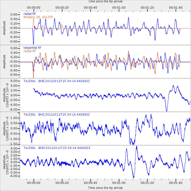
I28A Midland, SD, USA - Earthquake Result Viewer
*The percent match for this event was below the threshold and hence no stack was calculated.
| Earthquake location: |
Near East Coast Of Honshu, Japan |
| Earthquake latitude/longitude: |
35.6/141.5 |
| Earthquake time(UTC): |
2011/03/11 (070) 15:22:27 GMT |
| Earthquake Depth: |
35 km |
| Earthquake Magnitude: |
5.5 MB |
| Earthquake Catalog/Contributor: |
WHDF/NEIC |
|
| Network: |
TA USArray Transportable Network (new EarthScope stations) |
| Station: |
I28A Midland, SD, USA |
| Lat/Lon: |
44.00 N/101.17 W |
| Elevation: |
655 m |
|
| Distance: |
82.4 deg |
| Az: |
40.32 deg |
| Baz: |
313.084 deg |
| Ray Param: |
$rayparam |
*The percent match for this event was below the threshold and hence was not used in the summary stack. |
|
| Radial Match: |
50.7112 % |
| Radial Bump: |
400 |
| Transverse Match: |
35.348988 % |
| Transverse Bump: |
400 |
| SOD ConfigId: |
356183 |
| Insert Time: |
2011-08-17 09:28:52.799 +0000 |
| GWidth: |
2.5 |
| Max Bumps: |
400 |
| Tol: |
0.001 |
|
Signal To Noise
| Channel | StoN | STA | LTA |
| TA:I28A: :BHZ:20110311T15:34:14.449993Z | 0.9081248 | 4.960013E-7 | 5.4618187E-7 |
| TA:I28A: :BHN:20110311T15:34:14.449993Z | 2.0482733 | 8.439535E-7 | 4.1203168E-7 |
| TA:I28A: :BHE:20110311T15:34:14.449993Z | 1.2599595 | 1.0305301E-6 | 8.1790745E-7 |
| Arrivals |
| Ps | |
| PpPs | |
| PsPs/PpSs | |


