You are here: Home > Network List > TA - USArray Transportable Network (new EarthScope stations) Stations List
> Station H26A Fairpoint, SD, USA > Earthquake Result Viewer
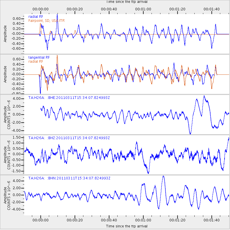
H26A Fairpoint, SD, USA - Earthquake Result Viewer
*The percent match for this event was below the threshold and hence no stack was calculated.
| Earthquake location: |
Near East Coast Of Honshu, Japan |
| Earthquake latitude/longitude: |
35.6/141.5 |
| Earthquake time(UTC): |
2011/03/11 (070) 15:22:27 GMT |
| Earthquake Depth: |
35 km |
| Earthquake Magnitude: |
5.5 MB |
| Earthquake Catalog/Contributor: |
WHDF/NEIC |
|
| Network: |
TA USArray Transportable Network (new EarthScope stations) |
| Station: |
H26A Fairpoint, SD, USA |
| Lat/Lon: |
44.62 N/102.77 W |
| Elevation: |
879 m |
|
| Distance: |
81.1 deg |
| Az: |
40.648 deg |
| Baz: |
312.014 deg |
| Ray Param: |
$rayparam |
*The percent match for this event was below the threshold and hence was not used in the summary stack. |
|
| Radial Match: |
48.315266 % |
| Radial Bump: |
400 |
| Transverse Match: |
38.51125 % |
| Transverse Bump: |
400 |
| SOD ConfigId: |
356183 |
| Insert Time: |
2011-08-17 09:29:27.378 +0000 |
| GWidth: |
2.5 |
| Max Bumps: |
400 |
| Tol: |
0.001 |
|
Signal To Noise
| Channel | StoN | STA | LTA |
| TA:H26A: :BHZ:20110311T15:34:07.824993Z | 0.9661364 | 7.873012E-7 | 8.148965E-7 |
| TA:H26A: :BHN:20110311T15:34:07.824993Z | 1.0520988 | 5.952408E-7 | 5.6576516E-7 |
| TA:H26A: :BHE:20110311T15:34:07.824993Z | 0.5801379 | 4.823512E-7 | 8.314422E-7 |
| Arrivals |
| Ps | |
| PpPs | |
| PsPs/PpSs | |


