You are here: Home > Network List > TA - USArray Transportable Network (new EarthScope stations) Stations List
> Station F27A Lemmon, SD, USA > Earthquake Result Viewer
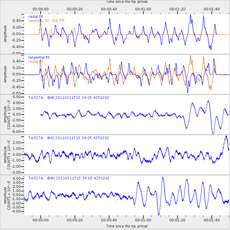
F27A Lemmon, SD, USA - Earthquake Result Viewer
*The percent match for this event was below the threshold and hence no stack was calculated.
| Earthquake location: |
Near East Coast Of Honshu, Japan |
| Earthquake latitude/longitude: |
35.6/141.5 |
| Earthquake time(UTC): |
2011/03/11 (070) 15:22:27 GMT |
| Earthquake Depth: |
35 km |
| Earthquake Magnitude: |
5.5 MB |
| Earthquake Catalog/Contributor: |
WHDF/NEIC |
|
| Network: |
TA USArray Transportable Network (new EarthScope stations) |
| Station: |
F27A Lemmon, SD, USA |
| Lat/Lon: |
45.87 N/102.02 W |
| Elevation: |
757 m |
|
| Distance: |
80.7 deg |
| Az: |
39.343 deg |
| Baz: |
312.341 deg |
| Ray Param: |
$rayparam |
*The percent match for this event was below the threshold and hence was not used in the summary stack. |
|
| Radial Match: |
51.75808 % |
| Radial Bump: |
400 |
| Transverse Match: |
57.716263 % |
| Transverse Bump: |
379 |
| SOD ConfigId: |
356183 |
| Insert Time: |
2011-08-17 09:31:03.204 +0000 |
| GWidth: |
2.5 |
| Max Bumps: |
400 |
| Tol: |
0.001 |
|
Signal To Noise
| Channel | StoN | STA | LTA |
| TA:F27A: :BHZ:20110311T15:34:05.425029Z | 0.62660724 | 6.7331496E-7 | 1.0745407E-6 |
| TA:F27A: :BHN:20110311T15:34:05.425029Z | 0.9550803 | 6.3340406E-7 | 6.6319456E-7 |
| TA:F27A: :BHE:20110311T15:34:05.425029Z | 0.60626704 | 3.8173795E-7 | 6.2965313E-7 |
| Arrivals |
| Ps | |
| PpPs | |
| PsPs/PpSs | |


