You are here: Home > Network List > TA - USArray Transportable Network (new EarthScope stations) Stations List
> Station X37A Clayton, OK, USA > Earthquake Result Viewer
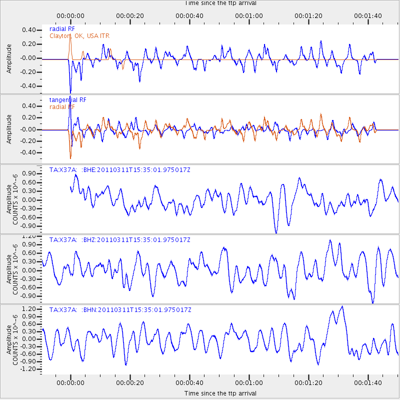
X37A Clayton, OK, USA - Earthquake Result Viewer
*The percent match for this event was below the threshold and hence no stack was calculated.
| Earthquake location: |
Near East Coast Of Honshu, Japan |
| Earthquake latitude/longitude: |
35.6/141.5 |
| Earthquake time(UTC): |
2011/03/11 (070) 15:22:27 GMT |
| Earthquake Depth: |
35 km |
| Earthquake Magnitude: |
5.5 MB |
| Earthquake Catalog/Contributor: |
WHDF/NEIC |
|
| Network: |
TA USArray Transportable Network (new EarthScope stations) |
| Station: |
X37A Clayton, OK, USA |
| Lat/Lon: |
34.59 N/95.37 W |
| Elevation: |
207 m |
|
| Distance: |
92.2 deg |
| Az: |
43.774 deg |
| Baz: |
316.917 deg |
| Ray Param: |
$rayparam |
*The percent match for this event was below the threshold and hence was not used in the summary stack. |
|
| Radial Match: |
38.341564 % |
| Radial Bump: |
312 |
| Transverse Match: |
45.39421 % |
| Transverse Bump: |
400 |
| SOD ConfigId: |
356183 |
| Insert Time: |
2011-08-17 09:50:19.912 +0000 |
| GWidth: |
2.5 |
| Max Bumps: |
400 |
| Tol: |
0.001 |
|
Signal To Noise
| Channel | StoN | STA | LTA |
| TA:X37A: :BHZ:20110311T15:35:01.975017Z | 0.88578594 | 4.471678E-7 | 5.04826E-7 |
| TA:X37A: :BHN:20110311T15:35:01.975017Z | 1.1714891 | 4.7527158E-7 | 4.0569867E-7 |
| TA:X37A: :BHE:20110311T15:35:01.975017Z | 0.8115082 | 2.5487958E-7 | 3.1408135E-7 |
| Arrivals |
| Ps | |
| PpPs | |
| PsPs/PpSs | |


