You are here: Home > Network List > TA - USArray Transportable Network (new EarthScope stations) Stations List
> Station O03D Paynes Creek, CA, USA > Earthquake Result Viewer
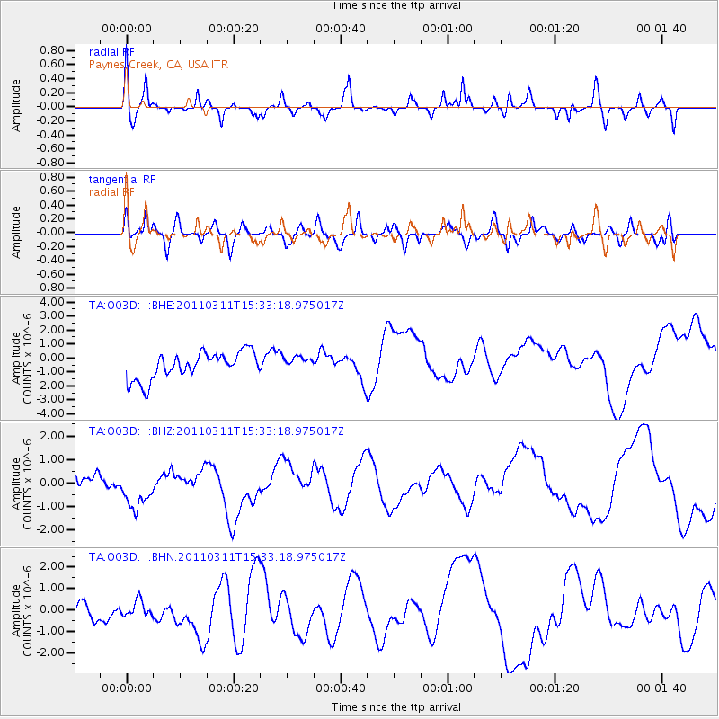
O03D Paynes Creek, CA, USA - Earthquake Result Viewer
*The percent match for this event was below the threshold and hence no stack was calculated.
| Earthquake location: |
Near East Coast Of Honshu, Japan |
| Earthquake latitude/longitude: |
35.6/141.5 |
| Earthquake time(UTC): |
2011/03/11 (070) 15:22:27 GMT |
| Earthquake Depth: |
35 km |
| Earthquake Magnitude: |
5.5 MB |
| Earthquake Catalog/Contributor: |
WHDF/NEIC |
|
| Network: |
TA USArray Transportable Network (new EarthScope stations) |
| Station: |
O03D Paynes Creek, CA, USA |
| Lat/Lon: |
40.29 N/121.80 W |
| Elevation: |
968 m |
|
| Distance: |
72.5 deg |
| Az: |
52.826 deg |
| Baz: |
301.942 deg |
| Ray Param: |
$rayparam |
*The percent match for this event was below the threshold and hence was not used in the summary stack. |
|
| Radial Match: |
35.802753 % |
| Radial Bump: |
337 |
| Transverse Match: |
40.081722 % |
| Transverse Bump: |
400 |
| SOD ConfigId: |
356183 |
| Insert Time: |
2011-08-17 09:59:19.460 +0000 |
| GWidth: |
2.5 |
| Max Bumps: |
400 |
| Tol: |
0.001 |
|
Signal To Noise
| Channel | StoN | STA | LTA |
| TA:O03D: :BHZ:20110311T15:33:18.975017Z | 1.6482012 | 7.3257195E-7 | 4.4446756E-7 |
| TA:O03D: :BHN:20110311T15:33:18.975017Z | 0.6771088 | 4.811134E-7 | 7.105407E-7 |
| TA:O03D: :BHE:20110311T15:33:18.975017Z | 0.5198407 | 5.00287E-7 | 9.623851E-7 |
| Arrivals |
| Ps | |
| PpPs | |
| PsPs/PpSs | |


