You are here: Home > Network List > TA - USArray Transportable Network (new EarthScope stations) Stations List
> Station C06D Leavenworth, WQ, USA > Earthquake Result Viewer
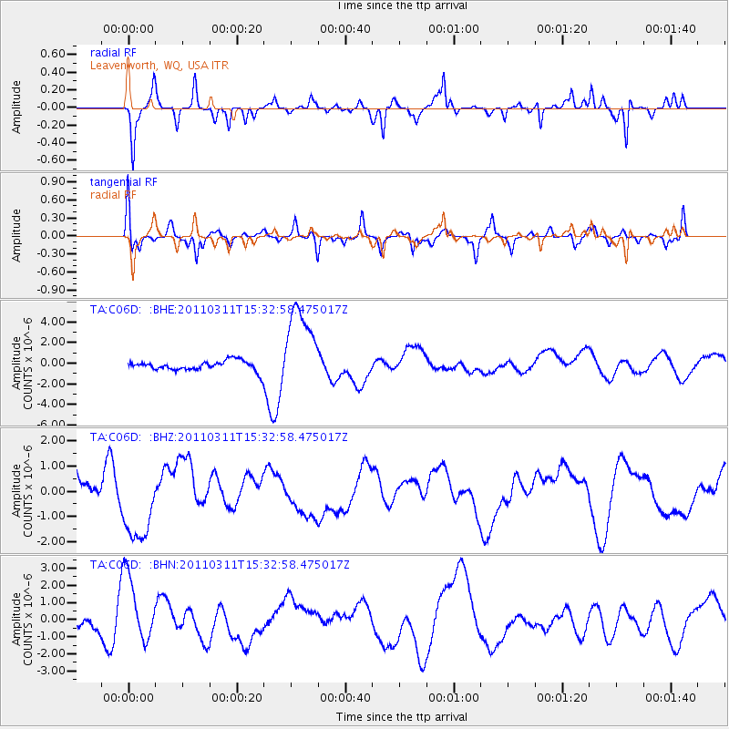
C06D Leavenworth, WQ, USA - Earthquake Result Viewer
*The percent match for this event was below the threshold and hence no stack was calculated.
| Earthquake location: |
Near East Coast Of Honshu, Japan |
| Earthquake latitude/longitude: |
35.6/141.5 |
| Earthquake time(UTC): |
2011/03/11 (070) 15:22:27 GMT |
| Earthquake Depth: |
35 km |
| Earthquake Magnitude: |
5.5 MB |
| Earthquake Catalog/Contributor: |
WHDF/NEIC |
|
| Network: |
TA USArray Transportable Network (new EarthScope stations) |
| Station: |
C06D Leavenworth, WQ, USA |
| Lat/Lon: |
47.92 N/120.89 W |
| Elevation: |
544 m |
|
| Distance: |
69.1 deg |
| Az: |
45.549 deg |
| Baz: |
300.171 deg |
| Ray Param: |
$rayparam |
*The percent match for this event was below the threshold and hence was not used in the summary stack. |
|
| Radial Match: |
47.69626 % |
| Radial Bump: |
235 |
| Transverse Match: |
46.477448 % |
| Transverse Bump: |
347 |
| SOD ConfigId: |
356183 |
| Insert Time: |
2011-08-17 10:04:31.249 +0000 |
| GWidth: |
2.5 |
| Max Bumps: |
400 |
| Tol: |
0.001 |
|
Signal To Noise
| Channel | StoN | STA | LTA |
| TA:C06D: :BHZ:20110311T15:32:58.475017Z | 2.1136925 | 1.2904721E-6 | 6.1052975E-7 |
| TA:C06D: :BHN:20110311T15:32:58.475017Z | 4.119453 | 2.0363152E-6 | 4.9431685E-7 |
| TA:C06D: :BHE:20110311T15:32:58.475017Z | 8.791261 | 4.1915628E-6 | 4.7678745E-7 |
| Arrivals |
| Ps | |
| PpPs | |
| PsPs/PpSs | |


