You are here: Home > Network List > TA - USArray Transportable Network (new EarthScope stations) Stations List
> Station G35A Watkins, MN, USA > Earthquake Result Viewer
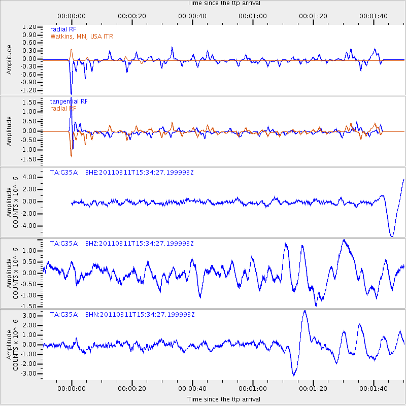
G35A Watkins, MN, USA - Earthquake Result Viewer
*The percent match for this event was below the threshold and hence no stack was calculated.
| Earthquake location: |
Near East Coast Of Honshu, Japan |
| Earthquake latitude/longitude: |
35.6/141.5 |
| Earthquake time(UTC): |
2011/03/11 (070) 15:22:27 GMT |
| Earthquake Depth: |
35 km |
| Earthquake Magnitude: |
5.5 MB |
| Earthquake Catalog/Contributor: |
WHDF/NEIC |
|
| Network: |
TA USArray Transportable Network (new EarthScope stations) |
| Station: |
G35A Watkins, MN, USA |
| Lat/Lon: |
45.22 N/94.49 W |
| Elevation: |
361 m |
|
| Distance: |
84.9 deg |
| Az: |
36.05 deg |
| Baz: |
317.293 deg |
| Ray Param: |
$rayparam |
*The percent match for this event was below the threshold and hence was not used in the summary stack. |
|
| Radial Match: |
61.586544 % |
| Radial Bump: |
262 |
| Transverse Match: |
49.047348 % |
| Transverse Bump: |
370 |
| SOD ConfigId: |
356183 |
| Insert Time: |
2011-08-17 10:06:05.724 +0000 |
| GWidth: |
2.5 |
| Max Bumps: |
400 |
| Tol: |
0.001 |
|
Signal To Noise
| Channel | StoN | STA | LTA |
| TA:G35A: :BHZ:20110311T15:34:27.199993Z | 0.6683647 | 2.9510045E-7 | 4.4152608E-7 |
| TA:G35A: :BHN:20110311T15:34:27.199993Z | 2.314322 | 5.97207E-7 | 2.5804837E-7 |
| TA:G35A: :BHE:20110311T15:34:27.199993Z | 0.7995045 | 2.0852748E-7 | 2.6082088E-7 |
| Arrivals |
| Ps | |
| PpPs | |
| PsPs/PpSs | |


