You are here: Home > Network List > TA - USArray Transportable Network (new EarthScope stations) Stations List
> Station F32A Veblen, SD, USA > Earthquake Result Viewer
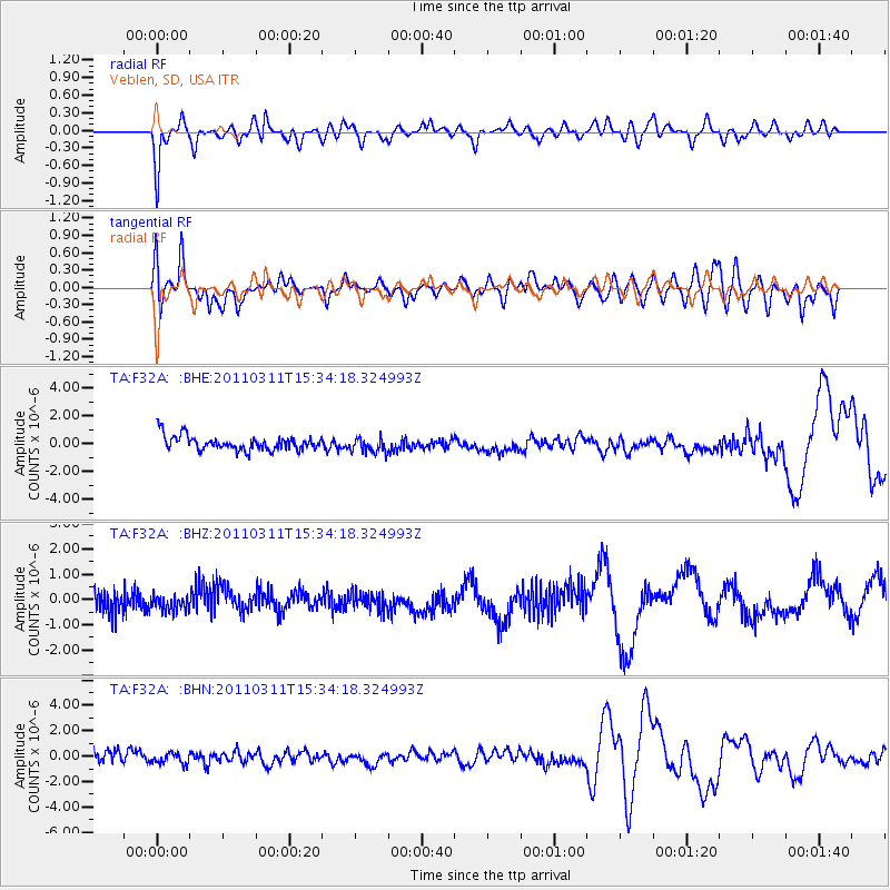
F32A Veblen, SD, USA - Earthquake Result Viewer
*The percent match for this event was below the threshold and hence no stack was calculated.
| Earthquake location: |
Near East Coast Of Honshu, Japan |
| Earthquake latitude/longitude: |
35.6/141.5 |
| Earthquake time(UTC): |
2011/03/11 (070) 15:22:27 GMT |
| Earthquake Depth: |
35 km |
| Earthquake Magnitude: |
5.5 MB |
| Earthquake Catalog/Contributor: |
WHDF/NEIC |
|
| Network: |
TA USArray Transportable Network (new EarthScope stations) |
| Station: |
F32A Veblen, SD, USA |
| Lat/Lon: |
45.87 N/97.13 W |
| Elevation: |
371 m |
|
| Distance: |
83.2 deg |
| Az: |
36.95 deg |
| Baz: |
315.507 deg |
| Ray Param: |
$rayparam |
*The percent match for this event was below the threshold and hence was not used in the summary stack. |
|
| Radial Match: |
58.16682 % |
| Radial Bump: |
400 |
| Transverse Match: |
62.431686 % |
| Transverse Bump: |
400 |
| SOD ConfigId: |
356183 |
| Insert Time: |
2011-08-17 10:10:31.861 +0000 |
| GWidth: |
2.5 |
| Max Bumps: |
400 |
| Tol: |
0.001 |
|
Signal To Noise
| Channel | StoN | STA | LTA |
| TA:F32A: :BHZ:20110311T15:34:18.324993Z | 0.6429772 | 4.0132306E-7 | 6.2416376E-7 |
| TA:F32A: :BHN:20110311T15:34:18.324993Z | 1.34024 | 5.868051E-7 | 4.3783584E-7 |
| TA:F32A: :BHE:20110311T15:34:18.324993Z | 1.0349606 | 5.398494E-7 | 5.2161346E-7 |
| Arrivals |
| Ps | |
| PpPs | |
| PsPs/PpSs | |


