You are here: Home > Network List > TA - USArray Transportable Network (new EarthScope stations) Stations List
> Station R39A Chumby, Stover, MO, USA > Earthquake Result Viewer
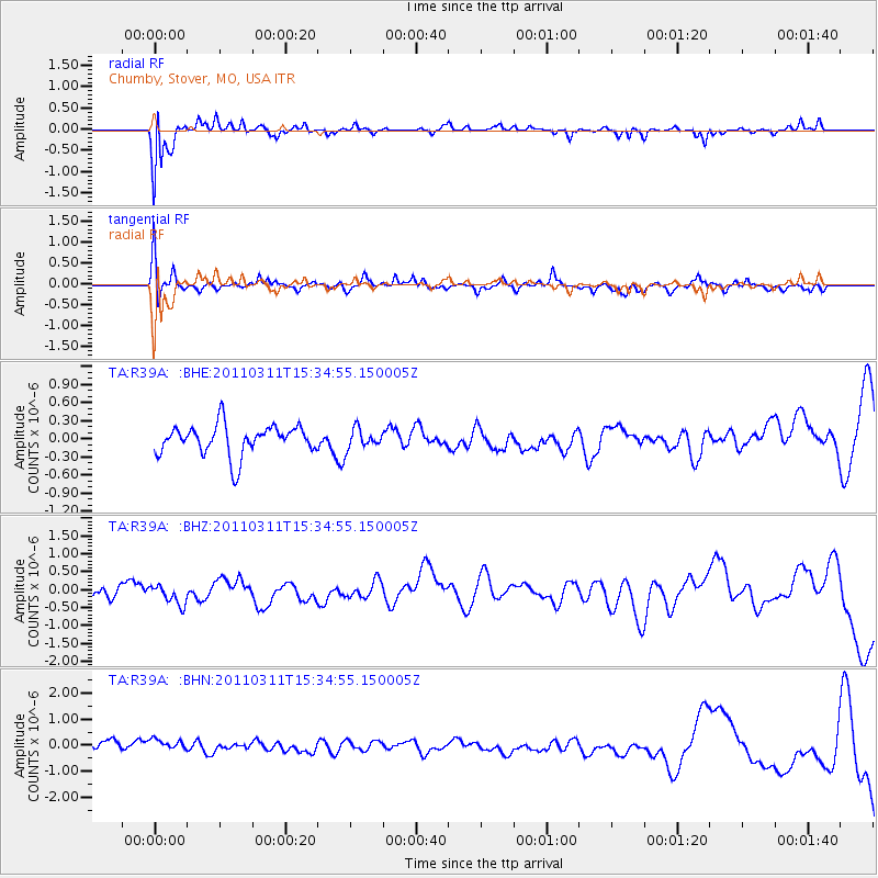
R39A Chumby, Stover, MO, USA - Earthquake Result Viewer
*The percent match for this event was below the threshold and hence no stack was calculated.
| Earthquake location: |
Near East Coast Of Honshu, Japan |
| Earthquake latitude/longitude: |
35.6/141.5 |
| Earthquake time(UTC): |
2011/03/11 (070) 15:22:27 GMT |
| Earthquake Depth: |
35 km |
| Earthquake Magnitude: |
5.5 MB |
| Earthquake Catalog/Contributor: |
WHDF/NEIC |
|
| Network: |
TA USArray Transportable Network (new EarthScope stations) |
| Station: |
R39A Chumby, Stover, MO, USA |
| Lat/Lon: |
38.31 N/93.04 W |
| Elevation: |
290 m |
|
| Distance: |
90.8 deg |
| Az: |
39.879 deg |
| Baz: |
318.4 deg |
| Ray Param: |
$rayparam |
*The percent match for this event was below the threshold and hence was not used in the summary stack. |
|
| Radial Match: |
82.083565 % |
| Radial Bump: |
299 |
| Transverse Match: |
63.891636 % |
| Transverse Bump: |
400 |
| SOD ConfigId: |
356183 |
| Insert Time: |
2011-08-17 10:14:48.877 +0000 |
| GWidth: |
2.5 |
| Max Bumps: |
400 |
| Tol: |
0.001 |
|
Signal To Noise
| Channel | StoN | STA | LTA |
| TA:R39A: :BHZ:20110311T15:34:55.150005Z | 0.72201425 | 2.594826E-7 | 3.593871E-7 |
| TA:R39A: :BHN:20110311T15:34:55.150005Z | 0.97495025 | 4.3385583E-7 | 4.4500302E-7 |
| TA:R39A: :BHE:20110311T15:34:55.150005Z | 0.6583973 | 1.6360106E-7 | 2.484838E-7 |
| Arrivals |
| Ps | |
| PpPs | |
| PsPs/PpSs | |


